
Share this @internewscast.com

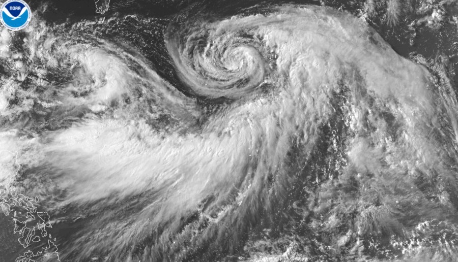
HONOLULU (AP) — Hurricane Iona has intensified into a Category 3 storm located several hundred miles south-southeast of Hawaii, but it is not expected to threaten the islands, according to meteorologists on Tuesday.
Iona is one of two major weather systems in the central Pacific Ocean.
The latest update from the U.S. National Hurricane Center in Miami reported Iona’s position at roughly 790 miles (1,271 kilometers) from Honolulu, with winds reaching up to 115 mph (185 kph).
Additional strengthening is forecast later on Tuesday, with steady weakening expected to begin by Wednesday.
Iona is the inaugural named storm of the central Pacific hurricane season, having developed from a tropical depression on Sunday. The hurricane continues its westward journey across the warm, open ocean.
Meanwhile, Tropical Storm Keli has maximum sustained winds of 40 mph (65 kph), the NHC said Tuesday morning. It was about 960 miles (1,550 kilometers) southeast of Honolulu and was moving west at about 12 mph (19 kph).
No coastal watches or warnings were in effect for the storms.
The administrator of the Hawaii Emergency Management Agency on Monday hosted a statewide conference call with all counties, during which the National Weather Service provided an assessment and status of the storms.
“All counties are monitoring,” agency spokesperson Kiele Amundson said in an email.
Another indirect impact from the weather systems could be swells, but they are relatively small and moving westward and won’t create anything significant, said Derek Wroe with the weather service in Honolulu..
However, a large swell is headed toward Hawaii after being generated several hundred miles east of New Zealand.
It’s expected to arrive in Hawaii by Thursday, about the same time the storms pass the state.
“People might wrongly attribute the swell energy to be from these tropical systems, but they’re actually not,” he said.