
Share this @internewscast.com
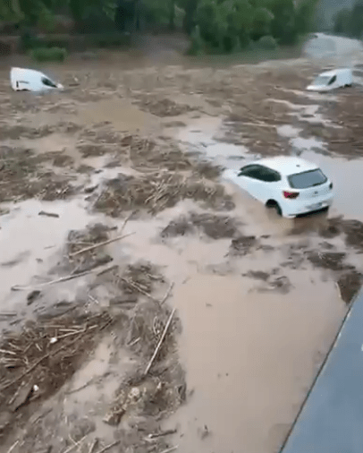
STREETS have been turned into rivers and cars left submerged in Spain as the country was pummelled by the elements today.
Jaw-dropping footage shows vehicles trapped in murky water in the wake of the vicious storms.


One clip even shows a car disappearing off a ledge as the foul weather took its toll.
Severe storm and hail warnings were issued in Spain – as 100mm of rain fell in just one hour at a holiday hotspot.
Both locals and visitors prepared for disruption following the State Meteorological Agency (AEMET) issuing weather alerts for 25 provinces, with eight of them receiving orange warnings.
AEMET predicted orange-level alerts for severe storms on Saturday in Huesca, Teruel, and Zaragoza, as well as in Barcelona, Girona, Lleida, Tarragona, and Castellón.
These areas have been experiencing intense rainfall and the threat of flash floods, which might interfere with holiday plans and result in significant damage to communities.
The DANA storm has caused the weather agency to activate red, orange and yellow warnings across dozens of Spanish regions.
The agency predicted rainfall of up to 50 litres per square metre in most of the regions in Aragon and Catalonia, which could spark local flooding and overflowing ravines.
The Ebro Riverbank in Tarazona, Zaragoza province, was under red alert on Friday after it was hit with severe flooding – with nearly 100mm of rain falling in just one hour.
It will remain under red alert until late on Saturday, following the extreme weather which caused urban flooding and transport disruption at the holiday hotspot.
The Military Emergency Unit (UME) was deployed to several towns in Zaragoza to help relieve the damage caused by the brutal rainfall.
Local rescue teams reported over 30 flood-related incidents, including fallen trees and blocked roads, but no casualties.
Shocking footage showed cars being swept away under the waves as intense rainfall pummelled Spanish streets.
Hailstorm was seen pelting the pavements as locals took shelter from the dangerous weather.
And streams of muddy water were seen flowing down streets while taking chairs and fences in their destructive paths.
There will also be storm warnings in several other regions, including Alicante and Valencia, Ribera del Ebro in La Rioja and Iberian Rioja, and Álava, among others.
Spain’s national forecaster said that unstable air was moving across the north and east of the Iberian Peninsula – bringing heavy showers, thunderstorms, and in some places, torrential downpours.


The worst parts of the storm will hit Catalonia, Aragon and the Valencian Community, where intense rain is likely from early Saturday.
Later in the day, the storms are expected to spread to the Cantabrian coast, the Balearic Islands, and parts of central and eastern Spain, before conditions begin to clear overnight.
While the rain lashes parts of the country, it will still be boiling hot in southeastern Spain, where temperatures could hit sweltering highs.
Reports say Murcia, Alicante, inland Andalusia, and parts of Extremadura will see temperatures approaching or exceeding 40 degrees.
The extreme heat will mark a sharp contrast to the torrential rainfall about to be seen in other parts of the country.
Temperatures will then drop in much of the mainland and the Canary Islands.
But winds will also pick up – especially in the Canary Islands and along the Alboran coast – potentially reaching strong to very strong levels.
The storm is reportedly a DANA phenomenon, or a “cold drop”.
The acronym stands for “Depresión Aislada en Niveles Altos,” which translates to “isolated depression at high altitudes”.
The phenomenon occurs when more warm and moist Mediterranean air than usual is sucked high into the atmosphere after a cold system hits the country.
The temperature difference between the cold air aloft and the warm surface air creates instability, leading to rapid uplift of warm, moist air and the formation of intense thunderstorms.