Share this @internewscast.com
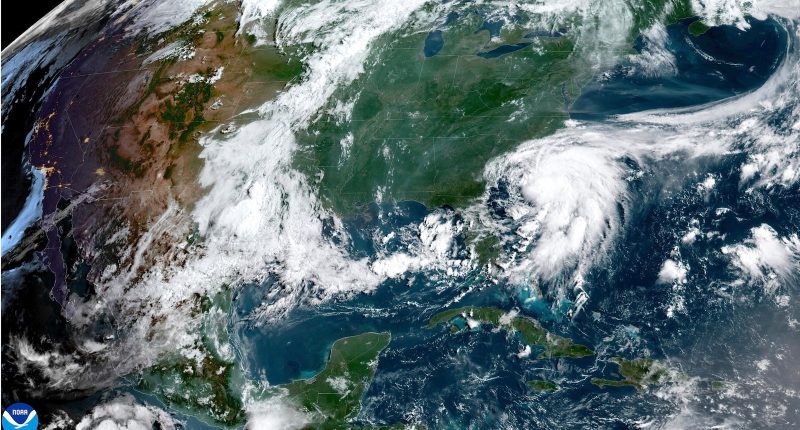
Tropical Storm Chantal has now been downgraded to a tropical depression after making landfall early Sunday.
The National Hurricane Center reports that the storm hit land close to Litchfield Beach, South Carolina. Chantal’s maximum sustained winds have now reduced to 35 mph, and it is advancing northward at a speed of 9 mph.
At 11 a.m. ET, Chantal’s center was positioned around 20 miles southwest of Lumberton, North Carolina, or roughly 80 miles west of Wilmington, North Carolina, as confirmed by the National Hurricane Center.
All tropical storm warnings have been discontinued and the storm is expected to dissipate later today.

An ABC News graphic shows landfall of Tropical Storm Chantal as of about 5 a.m. on Sunday, July 6, 2025.
ABC News
About an hour after making landfall at around 4 a.m. ET Chantal had weakened, with sustained winds then of up to 50 mph.
The storm’s outer bands continue to produce scattered showers and thunderstorms affecting parts of inland South and North Carolina. The inner bands, with denser showers and storms, are moving inland from the coastlines of both states.
The tropical storm watch has been discontinued from Edisto Beach to South Santee River, South Carolina, including Charleston.

An ABC News graphic shows the expected track of Tropical Storm Chantal as of 2 a.m. on Sunday, July 6, 2025.
ABC News

An ABC News graphic shows alerts for Tropical Storm Chantal as of 5 a.m. on Sunday, July 6, 2025.
ABC News
Chantal is expected to continue to weaken as it moves inland, likely becoming a tropical depression later today and dissipating by Monday.
The storm is forecast to produce scattered showers, and some areas will see heavy rain and gusty winds from thunderstorms throughout the day.
Flood watches remain in effect at least until Sunday night from Myrtle Beach to the west of Wilmington, North Carolina. Flood watches are expected to extend into parts of inland North Carolina, including Fayetteville and Raleigh, until Monday.

An ABC News graphic shows flood watches for Tropical Storm Chantal as of 5 a.m. on Sunday, July 6, 2025.
ABC News
Chantal, the third named storm of the Atlantic hurricane season, was forecast to bring 2 to 4 inches of rain to portions of the eastern Carolinas, with isolated amounts of up to 6 inches that could cause flash flooding.
Thunderstorms from the bands of Chantal may also produce isolated tornadoes, as well as lightning and gusty winds.
The storm was also expected to bring minor storm surges to parts of the Carolina coastline, with between 1 to 3 feet of storm surge possible during high tide for coastal areas under the tropical storm warnings.


