

ORLANDO, Fla. – Central Florida is in for another scorching day! The temperatures are predicted to rise into the low to mid-90s, but it will feel as hot as 100-103 degrees outside.
[STORY CONTINUES BELOW VIDEO FORECAST | SEE THE LATEST WEATHER ALERTS IN YOUR AREA BY CLICKING HERE]
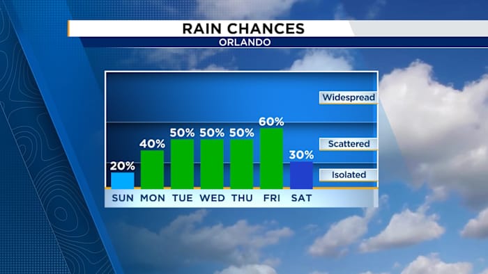
The chances of rain are slim, only about 10-20%, so expect a lot of sunshine with mild breezes. It’s a great day for beachgoers and boaters. Remember to use plenty of sunscreen since the UV index is very high!
Additionally, Saharan dust lingers in the air, which affects the air quality slightly, hovering at moderate levels. If you have sensitivity to air particles, consider spending some time indoors.
As we move into the week, the sea breeze will return, bringing with it a better shot at some rain — about 50-60% chances. It won’t be a total downpour everywhere, but expect some afternoon showers or storms in a few spots.
On the tropical front, things are pretty quiet across the Atlantic, Caribbean and Gulf for now, but the eastern Pacific is heating up.
Tropical Storm Barbara is likely to become a hurricane by Monday, and there are two other areas showing medium to high chances for development.
If they do form, the next names on the list are Cosme and Dalila.
Copyright 2025 by WKMG ClickOrlando – All rights reserved.