

ORLANDO, Fla. – Tropical Storm Erin on Thursday continues to gain strength in the open Atlantic.
While its exact path remains uncertain, the storm is expected to become a powerful hurricane over the weekend.
Strengthening and Watching Closely
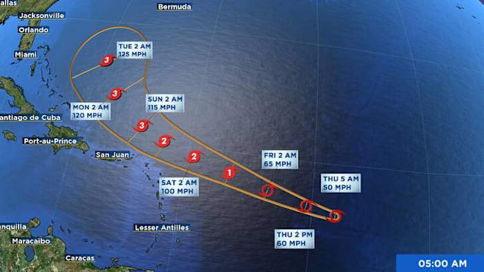
Erin continues to spin in the central tropical Atlantic, with sustained winds near 50 mph. Satellite imagery shows some ongoing development.
The conditions surrounding Erin are forecasted to become more conducive for strengthening within the next day or two. As the storm travels over warmer waters and faces reduced wind shear, forecasts suggest there is an opportunity for rapid intensification starting late Friday or Saturday. If this prediction proves accurate, Erin might evolve into a significant hurricane by the start of the following week.
At present, Erin is moving westward, but a shift to a west-northwest direction is anticipated soon. This movement is expected to persist throughout the weekend. Following that, with a weakening of the subtropical ridge to the north, Erin is projected to take the predicted rightward turn towards the north-northeast.
Forecasting models largely agree on Erin’s path in the coming days; however, the trajectory becomes uncertain afterward. Some models suggest Erin may head further east near Bermuda, while others propose a route closer to the Bahamas or possibly the U.S. East Coast.
Although it is premature to determine whether Erin will directly affect land, dangerous surf and rip currents are likely along the east coast of Florida, even in the absence of a formal landfall.
Areas in the Southwestern Gulf
Meanwhile, a widespread low-pressure area near the Yucatán Peninsula is resulting in disorganized rain and thunderstorms. This system is anticipated to move into the southwestern Gulf of Mexico by Thursday, where the development conditions remain only marginally favorable.
Any development would likely be short-lived, as the system is forecast to move inland over northeastern Mexico by late Friday.
At this time, chances for development are at 20% over the next 48 hours.
Looking Ahead
As we near the peak of hurricane season, it is crucial to remain attentive to the weather, particularly with the potential formation of a major hurricane in the Atlantic over the upcoming weekend.
Erin is still several days away from any possible interaction with land, but forecasts can shift and storms can strengthen quickly.
The next three named storms will be called Fernand, Gabrielle and Humberto.
Copyright 2025 by WKMG ClickOrlando – All rights reserved.