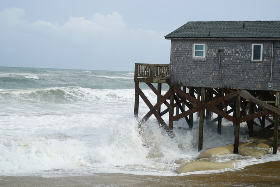


RODANTHE, N.C. (AP) — Hurricane Erin pounded North Carolina’s Outer Banks with powerful winds and waves, causing part of the main highway to flood and surging under beachfront homes as the formidable storm crept closer to the mid-Atlantic coast.
Meteorologists expected the storm to peak on Thursday and noted it could regain strength, possibly reverting to a major hurricane, Category 3 or higher. However, it was not projected to strike land along the East Coast before veering further out to sea.
The National Hurricane Center in Miami indicated that tropical storm conditions were likely over parts of the Outer Banks and the coast of Virginia. In Bermuda, warnings prompted residents and tourists to avoid the water, with rough seas anticipated through Friday.
As Erin’s outer bands reached the Outer Banks, water inundated the main roadway linking the barrier islands, affecting a few stilted homes vulnerable over the beach. By Wednesday evening, officials had shut Highway 12 on Hatteras Island due to increased surge and rising waves. Ocracoke Island’s connection to its ferry terminal was severed.
Officials forewarned that the most significant swells during high tide might isolate villages and homes on the Outer Banks, generating life-threatening rip currents from Florida to New England.
Beaches were closed to swimming on Wednesday and Thursday in New York City, with additional closures in New Jersey, Maryland, and Delaware. Widespread, moderate coastal flooding was predicted for low-lying regions of Long Island and parts of New York City.
Off Massachusetts, Nantucket Island could see waves of more than 10 feet (3 meters) later this week. But the biggest threat remained along the Outer Banks where longtime residents didn’t seem too concerned.
“I remember taking canoes out of my front yard to get to school, so I don’t think it’s gonna be that bad,” said Jacob Throne, who lives on Hatteras Island and works for surf shops.
Despite beach closures elsewhere, some swimmers continued to ignore the warnings. Rescuers saved more than a dozen people caught in rip currents Tuesday at Wrightsville Beach in North Carolina, a day after more than 80 people were rescued.
Bob Oravec, a National Weather Service forecaster, said that even if someone thinks they know how to handle a rip current, it’s not safe.
“You can be aware all you want,” he said. “It can still be dangerous.”
A combination of fierce winds and huge waves estimated at about 20 feet (6.1 meters) could cause coastal flooding in many beachfront communities, North Carolina officials warned.
“Dangerous conditions can be felt far from the eye, especially with a system as large as Erin,” said Will Ray, the state’s emergency management director.
Dozens of beach homes already worn down from chronic erosion and protective dunes could be at risk, said David Hallac, superintendent of the Cape Hatteras National Seashore.
Most residents decided to stay despite evacuations ordered on Hatteras and Ocracoke Islands.
“We probably wouldn’t stay if it was coming directly at us,” said Rob Temple, who operates sailboat cruises on Ocracoke.
His biggest concern was whether the main route would wash out and if tourists and delivery trucks may be cut off from the thin stretch of low-lying islands, which are increasingly vulnerable to storm surges.
Erin has become an unusually large and deceptively worrisome system, with tropical storm-force winds spreading across 500 miles (800 kilometers) — roughly the distances from New York City to Pittsburgh.
It remained a Category 2 hurricane early Thursday with maximum sustained winds around 105 mph (165 kph), the National Hurricane Center said. Erin was about 200 miles (320 kilometers) southeast of Cape Hatteras and moving north-northeast at 17 mph (28 kph).
The National Hurricane Center was also watching two tropical disturbances far out in the Atlantic that could develop into named storms in the coming days. With thousands of miles of warm ocean water, hurricanes known as Cape Verde storms are some of the most dangerous that threaten North America.
Climate scientists say Atlantic hurricanes are now much more likely to rapidly intensify into powerful and catastrophic storms, fueled by warmer oceans.
___
Seewer reported from Toledo, Ohio. Associated Press journalists Jeffrey Collins in Columbia, South Carolina; Gary Robertson in Raleigh, North Carolina; Ben Finley in Norfolk, Dave Collins in Hartford, Connecticut, Hallie Golden in Seattle and Julie Walker in New York contributed to this report.