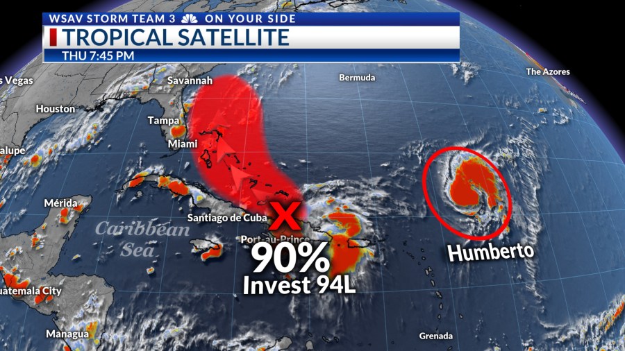

SAVANNAH, Ga. () — Impacts from a developing tropical system are becoming more likely for the southeaster U.S. coast early next week.
INVEST 94L
The National Hurricane Center is keeping an eye on a tropical wave, known as Invest-94L, which has been tracking through the northern Caribbean islands in recent days. As of Thursday evening, it is positioned near Hispaniola.
This system has a high probability (90%) of developing into a tropical depression or tropical storm as it moves west-northwest towards the Turks and Caicos and then the Bahamas in the coming days.

The potential exists for a tropical depression to form by tonight or Friday as the system organizes north of Hispaniola. However, any initial strengthening may be slow due to interactions with Hispaniola’s mountainous terrain.
As this system advances toward the Bahamas, it is expected to intensify into a tropical storm or hurricane over the weekend. Presently, there is considerable uncertainty regarding its track and intensity, but more information will become available as the system forms a clear center of circulation.

Various global and tropical computer models suggest that this system could potentially have significant impacts along the southeastern U.S. coast, particularly between Florida and North Carolina’s Outer Banks.
This situation is influenced by a cold front moving into the southeastern U.S., bringing rain and storms through tonight, Friday, and into the weekend. The front is predicted to stall in the area, increasing the likelihood of drawing Invest-94L towards the southeastern U.S. coast.

It is becoming possible for us to have impacts of some magnitude in the Coastal Empire and Lowcountry from this system. The timing for any impacts would be on Monday and into the day Tuesday. We will have a better idea on Friday and into the weekend. This could be a wind, rain, flood, and storm surge event wherever it makes landfall next week.
Now is the time to review your hurricane plan just in case this system brings significant impacts to our area.
TROPICAL STORM HUMBERTO
Tropical Storm Humberto is located about 440 miles northeast of the Northern Leeward Islands. It became stronger as of 5 p.m. EDT with sustained wind of now 60 mph. Wind gusts are now as high as 70 mph.
Humberto is forecast to intensify into a hurricane by Friday afternoon. The current intensity forecast from the National Hurricane Center calls for Humberto to become a major category 3 hurricane over the weekend as it inches just west of Bermuda. It will begin to weaken by Tuesday.
No significant impacts are expected to the east coast of the U.S. from Humberto at this time. However, higher surf is possible along the eastern seaboard.


