
SAVANNAH, Ga. — As a storm system approaches the area, the upcoming week promises both rain and a noticeable drop in temperatures starting Sunday.
Saturday offered residents a pleasant day, with a brisk morning giving way to a mostly sunny and breezy afternoon. However, as Saturday night progresses, expect cooler temperatures with increasing cloud cover, setting the stage for a predominantly cloudy start to Sunday.
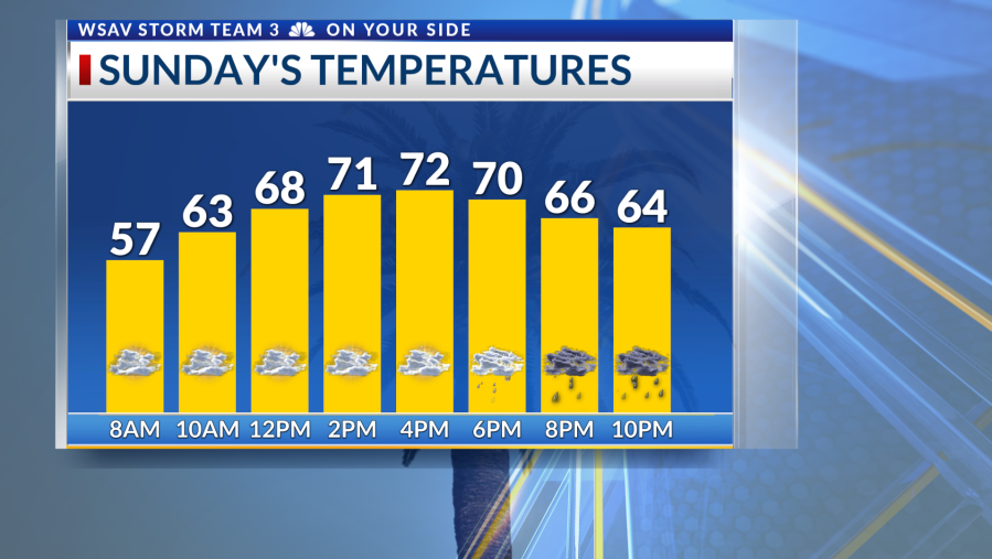
While Sunday morning will likely be dry, moisture accumulation in the mid-levels anticipates an uptick in rain chances by the evening. There’s a 30% probability of showers developing by Sunday evening and continuing into the night.
Monday will see the highest likelihood of scattered showers throughout the day. Although rainfall rates shouldn’t be overwhelming, there’s a possibility of localized street flooding in areas where heavy rain might linger. The region’s dry ground is expected to efficiently absorb the rain.
As the week progresses, temperatures will remain cool, with highs mostly in the 60s. From Tuesday through Thursday, there’s a persistent 30% chance of rain, ahead of a more robust cold front expected by week’s end. By Halloween next Friday, skies are anticipated to clear, ushering in chilly mornings and cooler-than-average daytime temperatures.
Tracking the Tropics
Meanwhile, in the tropics, Hurricane Melissa has intensified, reaching hurricane status by 2 p.m. on Saturday. The storm is expected to rapidly gain strength throughout the weekend, with potentially devastating effects forecasted for Jamaica from Sunday into Monday. Current projections suggest it could approach Category 5 strength as it moves south of the island.
The longer range forecast pulls the system to the northeast into eastern Cuba, then through portions of The Bahamas and Turks and Caicos. Cold fronts moving through the US will help keep this system away from North America. There are currently no tropical threats for the Coastal Empire and Lowcountry.


