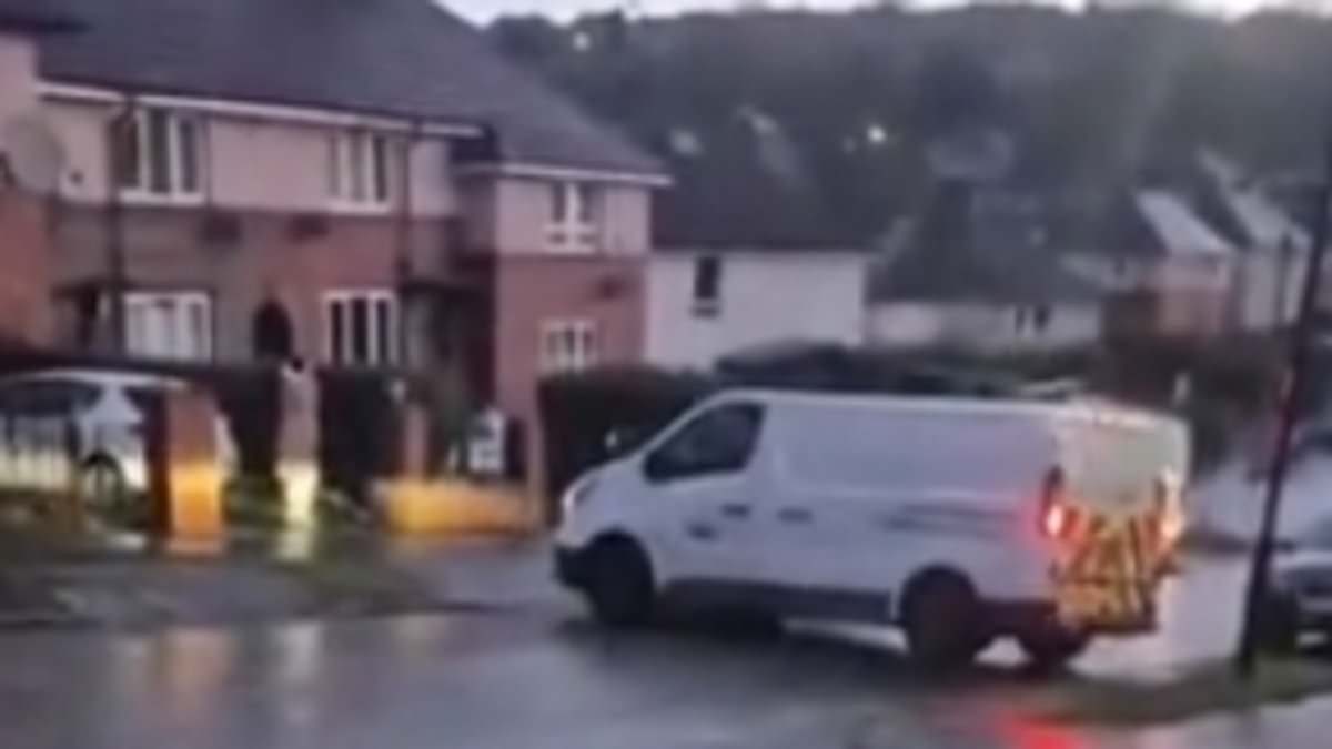

In a dramatic incident, a van skidded out of control on black ice, colliding with several parked cars in its path. The unsettling event unfolded in a suburban area of Sheffield, which has been battered by the wrath of Storm Goretti.
The footage, captured in shocking clarity, depicts the council van gliding helplessly down the residential street, unable to regain control. As the van careened into multiple parked vehicles, stunned residents could only watch as the situation unfolded.
The road was a treacherous mess, littered with vehicles scattered across the icy surface. The black ice, a deceptive layer created by a thin film of water freezing over the road, turned the street into a dangerous slide.
Throughout the ordeal, the individual recording the scene could be heard commenting on the chaos, remarking, “council for you” and expressing concern that “he’s not going to be alright.” His final words, “It is chaos,” aptly summed up the scene of disarray.
As the van slides down the road, the man filming the incidents is heard saying ‘council for you’ and ‘he’s not going to be alright’.
‘It is chaos’, he adds.
Elsewhere, there were reports of multiple vehicles crashing on snow and ice-hit roads, while high winds brought by Storm Goretti felled trees and brought travel chaos around the country.
The ‘weatherbomb’ brought heavy precipitation to Britain, with central areas seeing the ‘worst snowfall in a decade’

Deserted platforms and a departure board at Old Hill station in Sandwell, West Midlands, today

Falmouth University student Anna Richmond inspects the damage to her car this morning

An overturned van on the A30 near Blackwater in Cornwall today following Storm Goretti
The severe conditions caused widespread travel disruption across the UK today, with flights grounded at airports, roads blocked and large swathes of the rail network shut.
People in Cornwall were urged to work from home this morning, with the council advising residents to avoid travelling due to the large number of closed roads.
At least 69 flights scheduled to operate to or from Heathrow airport on Friday have been cancelled, likely disrupting more than 9,000 passengers.
The majority of the cancellations are short-haul flights by British Airways.
In a statement issued just after 6am, East Midlands Airport said its runway had reopened after being closed overnight due to heavy snow on the runway.
Passengers were warned delays may linger throughout the day.
Birmingham Airport said at 7.15am that its runway had reopened on a ‘reduced basis’ and teams were working to get passengers moving as efficiently as possible.
Rail services across England, Wales and Scotland may be affected until the end of the day on Friday due to the weather, National Rail said.
The storm, named by French weather forecaster Meteo France, was described as a ‘multi-hazard event’ by the Met Office.
The lowest temperature recorded overnight was minus 13.3C at Braemar, Aberdeenshire, while a peak gust of 99mph was reported at St Marys on the Isles of Scilly, the highest here since 1991, according to the Met Office.
Yellow weather warnings for snow and ice have been extended into Saturday for large parts of Scotland, England and Northern Ireland.
A yellow warning for snow and ice comes into force from midday Friday until 3pm on Saturday, with further snowfall possible across parts of northern England and much of Scotland, while a widespread risk of ice is expected to cause disruption.
A separate yellow warning for ice will cover large parts of England and Wales from midday on Friday until midday on Saturday as partially thawed snow refreezes, accompanied by wintry showers and freezing fog.
In Northern Ireland, a yellow warning for snow and ice will come into force from 5pm on Friday and run until 11am on Saturday, with the Met Office warning of icy patches and some hill snow.


Met Office yellow weather warnings are being imposed for tomorrow (left) and Saturday (right)
Meanwhile, skies across the West Midlands turned pink on Thursday evening with dramatic pictures capturing the unusual sight.
It was believed that lights from a football stadium was exacerbating the phenomenon.
Grahame Madge, Met Office spokesman, said: ‘The blue wavelengths of light are more easily scattered by snow or water droplets allowing the longer wavelengths – such as red and orange – to get through. This can have the effect of turning colours more pink or orange.’
Elsewhere, several shipping containers fell from two vessels off the Isle of Wight overnight, according to the Maritime and Coastguard Agency (MCA).
A number of refrigerated containers were reported falling into the sea from a cargo ship near Nab Tower at 11.10pm on Thursday and seven empty containers fell from the second ship which was 16 nautical miles south of St Catherine’s Point, Isle of Wight at 11.55pm.
Dozens of schools across the Midlands and Wales announced they would be closed on Friday where the amber weather warning was issued.
More than 250 schools were expected to remain closed in Scotland, including more than 150 in Aberdeenshire, dozens in the Highlands and Aberdeen, plus a number in Moray.
Forecasters also warned that the combination of melting snow and rain increases the flood risk for some in the coming days.
Following the storm, Birmingham Airport said in an update at 7.30am that its runway had reopened with a reduced service but urged passengers to check the status of their flight with their airline.
It said: ‘Our runway has reopened on a reduced basis, and our teams are working to get passengers away as efficiently as possible.
‘Whilst we apologise for any inconvenience Storm Goretti has caused, the safety of our colleagues and customers is our number one priority Passengers due to travel are advised to check the status of their flight with their airline.’
East Midlands Airport said at 6am that its runway had reopened after being closed overnight due to heavy snow on the runway, but passengers were warned delays may linger throughout the day.
British Airways cancelled 25 departures and 27 arrivals scheduled to operate at London’s Heathrow Airport today. The vast majority of affected flights were on short-haul routes.
Meanwhile the UK Health Security Agency (UKHSA) has extended its amber cold weather health alerts for all of England until Monday, warning of a ‘rise in deaths’.

People walk through the snow on Broad Street in Birmingham this morning after Storm Goretti

Damage caused by trees today after they fell during Storm Goretti in Falmouth, Cornwall
The wild weather brought 99mph winds overnight while a rare red warning was issued by the Met Office for ‘dangerous’ winds in South West England yesterday.
National Grid said 64,000 properties across England and Wales were without power this morning, including 48,000 in the South West and 15,000 in the West Midlands.
Birmingham and East Midlands airports both had to suspend operations due to the heavy snow, while all trains in Cornwall and many others in the North were axed.
The sky turned pink in areas of Birmingham this morning following the ‘weather bomb’, after the central pressure in the area of low pressure fell rapidly yesterday.
Roads were also closed due to fallen trees following a week of severe conditions that has seen villages in Scotland cut off and temperatures falling to nearly -15C.
People in Cornwall were urged to work from home this morning, with the council advising residents to avoid travelling due to the large number of closed roads.
While the influence of Storm Goretti will reduce through today as it gradually moves towards mainland Europe, the system is expected to bring more rain to eastern England.
The Met Office said conditions would gradually improve with a ‘period of respite for many on Saturday with some sunny spells at times’, despite the further snow in northern areas and Wales.
But forecasters said this calmer period for many will be ‘relatively short-lived, as another front arrives from the west on Sunday’, bringing the risk of further snow.
Met Office chief forecaster Steve Willington said: ‘Following on from a Saturday which will be largely dry away from northeastern parts of Scotland and England, a front from the west on Sunday will bring snow for parts of Scotland and northern England with low temperatures continuing the ice risk.
‘A further 2cm to 5cm of snow is possible to accumulate at low levels within the warning area on Sunday, with 10cm to 20cm possible over higher ground.
‘With much of this falling in areas that have already seen severe snowfall, ongoing disruption is likely. Those in central and southern England and Wales will see this fall as rain, in what will be a wet Sunday for many.’
The Met Office said temperatures will return closer to average for most through next week, with a south-westerly regime dominant – although there could be more unsettled weather at times as low pressure continues to influence the weather.
The Government was urged to convene a meeting of the emergency Cobra committee to respond to Goretti.
The storm brought winds of almost 100mph after forecasters issued a rare red warning for ‘dangerous, stormy’ winds in the South West.
More than 40,000 properties were without power in the South West just before 2pm on Friday, according to the National Grid’s website; about 9,000 had no power in the West Midlands; more than 700 had no power in the East Midlands; and more than 200 were without power in Wales.
Downing Street said support was being offered to homes left without power.
A No 10 spokesman said: ‘The latest data I have is that around 0.21% of British customers are without power.
‘Engineers and staff are working to reconnect them as quickly as possible. The latest numbers I have is approximately 150,000 customers have had their power restored so far.’