
Significant rainfall is anticipated for regions of South Australia, including Adelaide, as meteorologists issue a flood watch across much of the state.
Heavy showers and thunderstorms are expected to sweep across Adelaide and other areas today, driven by a slow-moving pressure system advancing from central Australia toward the eastern coast.
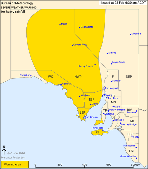
A severe weather warning has been issued for several areas, including South Australia’s West Coast, Lower and Eastern Eyre Peninsula, Kangaroo Island, North West Pastoral, and parts of the Yorke Peninsula and North East Pastoral regions.

“Our expectations are that this weather system will be quite dynamic, expanding over the weekend, particularly impacting eastern parts of South Australia and moving towards western Victoria,” Jonathan How from the Bureau of Meteorology explained yesterday.
The weather system has the potential to deliver rainfall of up to 70 millimeters within a six-hour period today, with forecasts predicting up to 80 millimeters tomorrow.
The system could cause falls of up to 70 millimetres in six hours today, and 80 millimetres tomorrow.
Isolated totals of up to 150 millimetres to 200 millimetres are also possible.
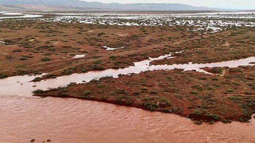
The Bureau of Meteorology has warned that flash flooding is expected from the intense rain as a large tropical low finally shifts south over the weekend.
The state’s south-east is likely to be affected, with multiple flood warnings in place for the capital.
“Sunday night will be the main risk period for Adelaide and south-eastern parts of South Australia,” How said.
“Really, depending on where this trough and low-pressure system do sit, we can see Adelaide is on the edge of that heavier rain, but we could see flash flooding developing across the city as we head into Monday morning as well.”
How said that while the wet weather will be welcome for the dry parts of the state, it will also bring about new challenges.
“With heavy rain, that could lead to flash and river rain flooding and this could create dangerous travel, as well as driving conditions and number of roads and freight and trade lines are already impacted,” he said.
“For some parts of the south-east, this rain will be very welcome, particularly through western parts of Victoria and south-eastern parts of South Australia, but that will come with its challenges, including top soil, which may become washed away, as well as generalised flooding right across the region.”
How said the conditions will ease from Monday and then clear by Tuesday.
Gloomy conditions are also gripping other parts of the nation, with rain expected across parts of Victoria and NSW this weekend.
The conditions come as Sydney continues to recover from heavy rainfall that resulted in flash flooding in some parts of the city.
Homes were evacuated as the rain inundated streets in Fairfield East, and more than 490 calls were made to the SES.
Out of those, 42 led to swiftwater rescues.
The rain eased throughout yesterday morning, with the Bureau of Meteorology cancelling a severe warning for Greater Sydney later in the day.
Marine wind warnings are in place across the state’s seaside regions, including the Central Coast, Central Gippsland Coast and East Gippsland Coast.
Parts of the state also remain on flood watch with heavy rainfall expected that could lead to minor flooding in the north-west and south-west regions.
These warnings are expected from overnight Sunday into Monday.
Rain also continues to bucket down in dust-dry outback Queensland, with the tiny town of Birdsville, 10km from the South Australian border, copping an extremely rare drenching.
NEVER MISS A STORY: Get your breaking news and exclusive stories first by following us across all platforms.