

After enduring a tough winter, Americans are eagerly anticipating a fresh start this March, a month often associated with the transition to milder weather.
Although many regions in the United States will enjoy a welcome rise in temperatures, this seasonal change also brings a heightened risk of severe weather conditions.
Beginning Tuesday evening, a notable shift in weather patterns is expected as an atmospheric disturbance travels through the Desert Southwest and the Rockies.
This disturbance is likely to trigger scattered thunderstorms across the mid-Mississippi Valley.
Experts at the FOX Forecast Center predict these storms will form above a cooler layer near the ground, classifying them as elevated thunderstorms.
The NOAA Storm Prediction Center has issued a level 1 out of 5 risk for Tuesday, with large hail posing the most significant threat.
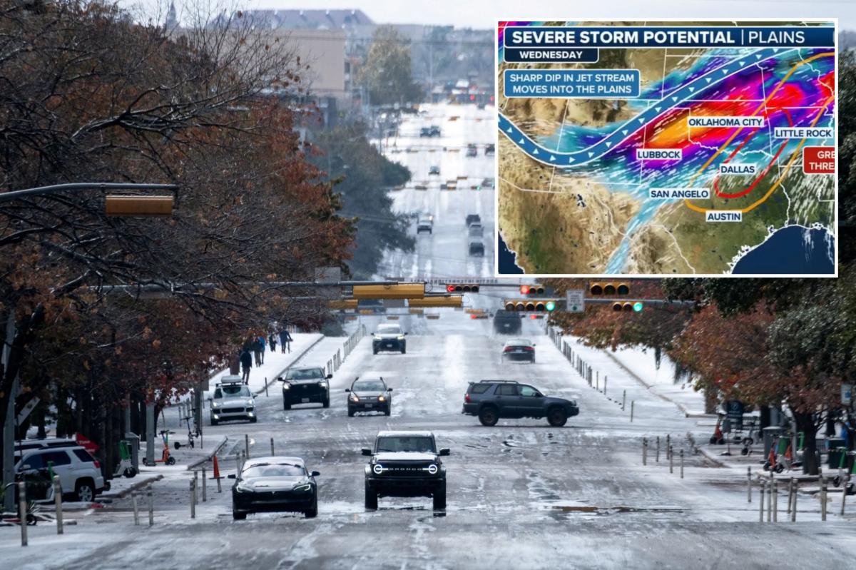
As we transition into Wednesday, warm, humid air will spread northward from east-central Texas into the Arkansas and Louisiana regions.
At this point, thunderstorms will likely develop from Central Oklahoma into Southern Missouri.
Forecast models are predicting a decent amount of storm energy ahead of this, with stronger winds moving through the Southern Plains by Wednesday afternoon, providing enough wind shear for organized storms.
A few supercells are possible, which is the greatest overall risk.
Since 2010, more than 1,700 tornadoes have been recorded in the month of March.
Due to these factors, the Storm Prediction Center is issuing a level 2/5 risk for Wednesday with all modes of severe weather possible.
Thursday through Saturday
The multi-day storm threat extends across the Central and Southern Plains through the weekend.
According to the FOX Forecast Center, the storm system will move into the mid-Mississippi Valley on Thursday. At the same time, a cold front pushes southeast into the Arkansas, Louisiana, and Texas regions.
“Thunderstorms will remain possible along and ahead of the front during the day and into the evening,” a statement from the FOX Forecast Center reads. “However, severe weather ingredients look somewhat weaker than on Wednesday, which should limit the overall severe threat.”
Despite the weakened threat, severe weather is expected to persist on Thursday.
This won’t last long, as forecast models generally agree that starting on Friday, moist air will become unstable enough to support scattered thunderstorms.
This storm development will be aided by a strengthening jet stream moving Northeast across the Southern Plains.
This factor will produce stronger winds, which can organize storms that are likely to become severe.
According to the FOX Forecast Center, the greatest risk of severe weather stretches from Central Texas into the lower Missouri Valley, including popular locations such as Dallas, Oklahoma City, and Kansas City.
The main threats to these areas are large hail and damaging wind gusts; a few tornadoes can’t be ruled out, especially if storms become more organized.
By Saturday, a stronger, larger upper-level trough is expected to form over the Western U.S., reinforcing warm, humid air.
Given the likelihood of severe storms forming, the Storm Prediction Center has already issued a Day 6 severe weather outlook from north-central Texas into the Arkansas and Louisiana regions.