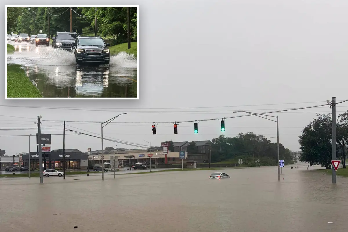

Successive waves of dangerous flash flooding inundated the Ohio Valley on Saturday, forcing evacuations and water rescues as Kentucky faced multiple Flash Flood Emergencies during a prolonged period of relentless, heavy rain.
At least one driver died after being swept away by floodwaters in Kentucky, Gov. Andy Beshear said. Beshear declared a statewide State of Emergency as flooding spread across the Commonwealth, cautioning that the situation is “much more severe than most would have thought.”
In Jackson County, a Flash Flood Emergency was issued for McKee, Sandgap and Clover Bottom as life-threatening flooding overtook communities. Emergency responders carried out numerous water rescues while fast-rising water covered roads and low-lying neighborhoods.
To the west, parts of Madison County were also placed under a Flash Flood Emergency after repeated rounds of thunderstorms moved over ground already saturated by earlier rainfall, intensifying flash flooding and making travel extremely dangerous.
Images released by the Richmond Police Department showed streets swallowed by floodwater as emergency crews handled multiple calls for water rescues throughout the area.
With life-threatening flooding still unfolding across Kentucky, local states of emergency have been declared in Bullitt, Madison, Meade, Mercer and Spencer counties.
In Bullitt County, officials ordered an immediate evacuation for a section of Lebanon Junction after emergency management authorities reported that a dam had experienced a “moderate” failure.
The community was one of several locations placed under Flash Flood Warnings across Kentucky, Indiana and nearby areas as intense rainfall sent creeks and streams rising quickly.
According to the FOX Forecast Center, widespread rainfall totals of 3 to 5 inches have fallen across portions of the Ohio Valley, with locally higher amounts contributing to flash flooding and rapidly rising waterways.
READ MORE: Video Captures Fiery Plane Crash on Highway as Aircraft Breaks in Two
Most Flash Flood Warnings are expected to expire by early Sunday as the widespread flooding threat gradually eases. However, the weather won’t turn completely dry. Warm, moisture-laden air will continue to fuel scattered showers and a few thunderstorms across central and south-central Kentucky through the afternoon.
In eastern Kentucky, near-record atmospheric moisture will keep the atmosphere capable of producing locally heavy downpours through at least the first half of Sunday, meaning isolated flooding issues can’t be ruled out.
Farther east, the same storm system will continue to bring showers and thunderstorms to portions of the Mid-Atlantic and Northeast before drier air gradually spreads into the Ohio Valley later Sunday.
After severe weather developed Friday afternoon over parts of the Midwest, as well as much of northern New England, storms over the lower Ohio Valley, in particular, are threatening to produce heavy rain, prompting NOAA’s Weather Prediction Center to issue a Level 2 out of 4 risk of flash flooding through Saturday morning.
A Level 3 flash flood risk covers parts of northeastern Oklahoma, southeastern Nebraska and southwestern Missouri. This broader pattern is responsible for bringing 5.31 inches of rain to Wichita, Kansas, on Thursday.
By Saturday afternoon, showers and thunderstorms will likely reach the northern Ohio Valley, the Mid-Atlantic, and the Northeast — including the Cincinnati, Washington, D.C., and New York City metro areas.
Heavy downpours and severe storms battered the Northeast and along the Interstate 95 corridor earlier this week, prompting the NYNJ 2026 World Cup Fan Fest in Queens to close early and delaying the FIFA World Cup match between France and Iraq in Philadelphia.
Farther south, a few stronger storms could reach eastern North Carolina and Eastern Virginia by Saturday afternoon. NOAA’s Storm Prediction Center has issued a Level 2 out of 5 risk of severe thunderstorms for this area, including Richmond.
By early Sunday, widespread rainfall totals of 1 to 2 inches are possible from southern Indiana through West Virginia, Pennsylvania, and New Jersey, with localized amounts exceeding 3 inches possible where slower-moving thunderstorms develop.
Some lingering showers are possible Sunday across parts of the Northeast with leftover instability in the atmosphere before drier and more seasonable weather is expected to return by Monday.
A heat dome is expected to form over much of the Central and Eastern U.S. by midweek, sending temperatures into the 90s ahead of the July 4th holiday.