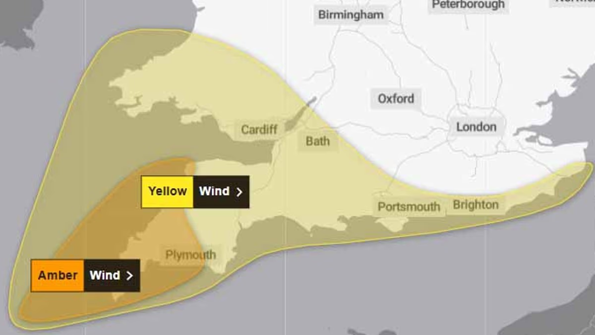

The Met Office has issued an amber warning for winds reaching 80mph as Storm Austen, the first named storm of the season, moves closer to the UK.
The storm is intensifying over the Atlantic and is expected to strengthen further before reaching Britain early on Friday.
The amber alert—the Met Office’s second-highest level of warning—covers Cornwall, Devon, Plymouth and the Isles of Scilly from 3am until 10pm on Friday.
A separate yellow wind warning will affect southern England and Wales from midnight until midday on Friday.
Exposed coastal areas could see gusts of up to 80mph (130km/h), while much of the region may experience winds reaching between 60mph and 70mph.
Forecasters have also issued a yellow rain warning for parts of southern and eastern Scotland, running from 6am on Friday until 3am on Saturday.
Rainfall totals of 20mm to 40mm are expected in affected areas, although some locations could receive as much as 80mm.
The warning stretches across large parts of Scotland, reaching from the Borders and Dumfries and Galloway in the south to Fraserburgh in Aberdeenshire.

An amber weather warning has been issued for winds of up to 80mph as Storm Austen, the season’s first named storm, approaches Britain (pictured, pedestrians on London Bridge)

The second-highest Met Office warning covers Cornwall, Devon, Plymouth and the Isles of Scilly from 3am to 10pm on Friday (pictured)
Western areas including Ayrshire, Lanarkshire and Glasgow are among those expected to be affected, while much of eastern Scotland is also forecast to see heavy rain.
The Met Office warns there is a “small chance” that homes and businesses could be flooded, potentially causing damage to buildings.
People living beneath the amber warning should expect possible disruption to road, rail, air and ferry services, including cancellations and significantly longer journey times.
Flying debris, powerful waves and beach material thrown onto sea fronts and coastal roads could create a risk of serious injury or danger to life.
The storm may also lead to power cuts, which could disrupt mobile phone coverage, while buildings could be damaged by items such as roof tiles being blown loose.
The Met Office is advising residents in affected areas to secure loose outdoor objects, including wheelie bins, trampolines and garden furniture.
Households should also prepare torches, spare batteries, a mobile phone power bank and other essential supplies before the storm arrives.
Anyone planning to travel by public transport on Friday or over the weekend should check the latest bus and train timetables before setting out.

Gusts could reach 80mph (130km/h) along exposed coasts, with winds of 60mph to 70mph expected more widely elsewhere (pictured)

London experienced persistent drizzle on Wednesday, with temperatures forecast to reach only 11C—well below the 20C recorded last week (pictured, pedestrians on London Bridge)
The amber warning is also likely to force some roads and bridges to close.
Residents living in the areas under the warning have been urged to stay indoors as much as possible to avoid the strong winds.
The windiest conditions are forecast for coastal headlands in north and west Cornwall, however gusts of 70mph could occur in inland areas.
KEEP READING: Matthew McConaughey Faces Backlash for Not Endorsing Democrats
The Met Office said the weather is expected to remain unsettled through the weekend and into next week while low pressure is likely to bring strong winds to northern parts of the UK on Saturday and Sunday.
Deputy chief forecaster Chris Bulmer said: ‘Storm Austen is expected to bring a spell of impactful weather to parts of the UK from Thursday night and through Friday.
‘While there remains some uncertainty in the exact track of the storm, there is increasing confidence in the potential for disruptive winds across parts of southwest England, which is why an amber warning has been issued.
‘Wind gusts could potentially reach 60-70mph for a time, and these strong winds will be combined with spells of heavy rain.
‘People in affected areas should keep up to date with the latest forecast and warnings as the event develops.’

Storm Austen is set to batter Britain this weekend as families prepare to travel for half-term
Londoners woke to a steady drizzle on Wednesday, with temperatures expected to reach just 11C – a stark contrast to the 20C warmth last week.
Heavy rain will begin lashing the capital from 11pm on Thursday with the wet and wild weather to continue long into Friday.
Strong winds are forecast on Saturday, with showers in the afternoon. Sunday will bring slightly warmer and drier conditions, with highs of 17C.
Families heading to the coast for half-term have been encouraged to ‘keep a close eye’ on the forecast, which the AA warned will make driving ‘much more difficult’.
A spokesman for the AA, Tony Rich, urged drivers heading to the coast to take care.
He said: ‘With half-term approaching, many families will be looking forward to getting away, so we’d encourage anyone travelling towards areas affected by the forecast to keep a close eye on weather and travel updates before setting off.
‘Strong winds and heavy rain can make driving much more challenging, particularly on exposed roads and for those towing caravans or trailers.
‘Allow extra time, reduce your speed to suit the conditions and leave more space between you and the vehicle ahead.’

Torrential rain and strong winds are on the way to parts of England and Wales this week
Ross Macleod, RNLI water safety manager, has asked people not to take ‘unnecessary risks’ when visiting the coast.
He said: ‘If you plan to visit the coast or a waterside location, we urge you to stay a safe distance from the water as conditions could knock you off your feet or wash you into the sea.’
News of an impending downpour may, however, be welcomed in some areas after the hottest summer ever recorded in Britain.
Only last week a ‘severe drought’ was declared in Cornwall, Devon, Dorset, Somerset, East Sussex and West Sussex by the Environment Agency.
Water companies were urged to step up drought planning amid concerns about supplies as millions of people remain under a hosepipe ban.
Water storage levels have plummeted to just 31 per cent overall in Devon and Cornwall, while specific reservoirs have seen their capacities plummet.
The Met Office storm year runs from September to August, with each 12-month period having its own alphabetical list of names that are used to label storms.
This year’s list begins with Austen and continues with Boelo, Chloe, Dano and Evelyn, ending at W with Wende. They were chosen from more than 40,000 names after the weather authorities invited the public to make suggestions last year.