
Share this @internewscast.com
TAMPA, Fla. (WFLA) The National Hurricane Center is monitoring two tropical waves in the Atlantic for potential development this week.
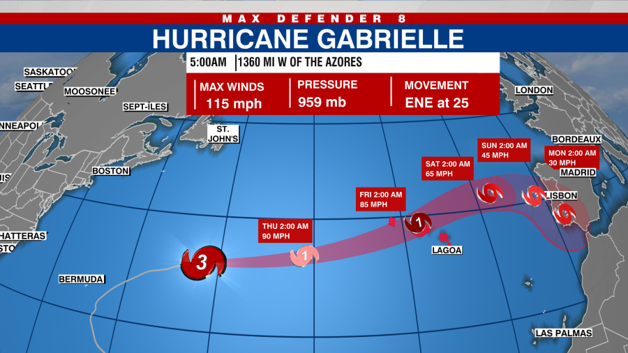
This development follows Gabrielle, currently a Category 2 storm, as it progresses through subtropical waters towards the Azores, triggering the first Hurricane Warning of the 2025 season.
Hurricane Gabrielle

Located about 1,100 miles west of the Azores, Gabrielle is moving toward the east at 26 mph. Maximum sustained winds are 110 mph.
Gabrielle is predicted to accelerate as it nears the Azores on Thursday, continuing over the island chain from Thursday night into Friday. Despite an expected weakening in the days ahead, the storm is anticipated to retain hurricane status while passing through the islands.
A Hurricane Warning is in effect for all of the Azores.
Central and western tropical Atlantic (AL93)
A tropical wave located about several hundred miles east of the Leeward Islands became better organized on Wednesday.
The NHC said that if this trend continues, advisories could be issued for a tropical depression or storm later Wednesday or Wednesday night.
It has a 90% chance of development in the next 48 hours.

Eastern Caribbean Sea (AL94)
Meanwhile, a tropical wave located over the northeastern Caribbean Sea is generating rain, thunderstorms, and winds across the Windward and Leeward Islands, though it remains disorganized, according to the NHC.
Heavy rainfall and winds are expected in Puerto Rico and the Virgin Islands before moving to the Dominican Republic on Wednesday night.
The NHC reports that the system is projected to decelerate and shift northwestward upon reaching the southwestern Atlantic within the coming days. There is potential for a tropical depression to form later this week as the system approaches the region near the Bahamas.
A Hurricane Hunter aircraft is enroute to investigate the disturbance.
Its chance of formation in the next 48 hours is 30%. It has an 80% chance of development in the next seven days.