
Share this @internewscast.com
ORLANDO, Fla. – In the southwestern Atlantic, a tropical system is rapidly forming, increasing the likelihood that Invest 94L will transform into Imelda in the coming days.
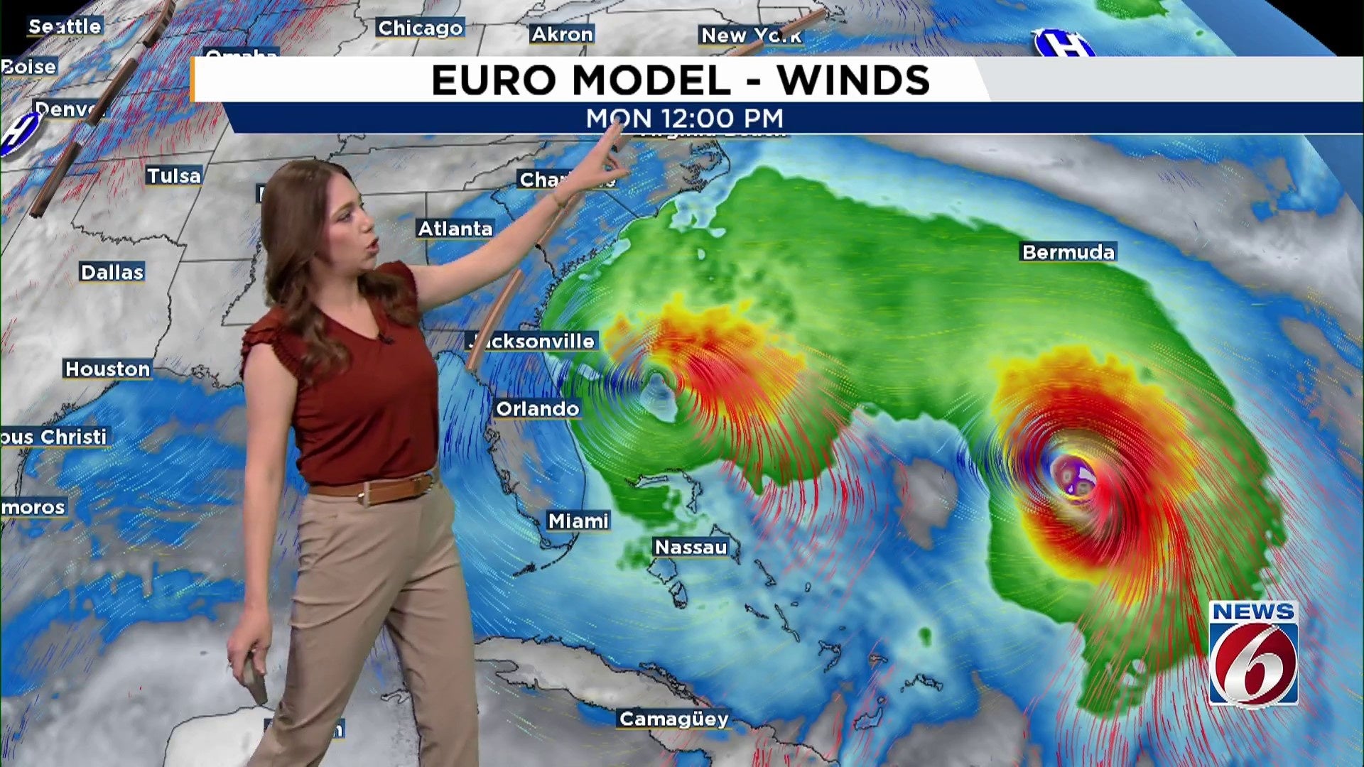
Meantime, Humberto strengthened into a hurricane early Friday.
AL94 – Imelda Likely by Weekend
Currently, Invest 94L consists of a tropical wave stretching from Hispaniola to the southern Caribbean, with development anticipated near the southeast Bahamas by Friday.
The environment supports intensification, giving the system a strong probability (80-90%) of evolving into a tropical depression or storm, to be named Imelda, within the next day or so as it moves in a north to northwest direction across the southwestern Atlantic.
While there’s still uncertainty in the long-range track and intensity, chances are increasing for impacts to the U.S Southeast early next week.
Model consensus is leaning towards a Georgia/Carolina landfall, but Florida is not completely out of the woods just yet.
Gusty winds, heavy rainfall, and coastal hazards are all possible depending on how close the system tracks to the coastline.
[VIDEO BELOW: How to track tropics in News 6 Weather App]
Hurricane Humberto Strengthens
Just a few hundred miles east of Invest 94L, Humberto has officially become a hurricane.
The forecast calls for the hurricane to rapidly intensify to a major hurricane this weekend as it tracks toward Bermuda.
Though not immediately threatening land, Humberto still plays a significant role, as some forecasts suggest a potential Fujiwhara effect between Humberto and Invest 94L early next week.
With this interaction, both storms could begin to rotate around each other, influencing the path of both storms.
This scenario is one big reason why forecast confidence isn’t as high.
What It Means for Florida
As 94L progresses and likely becomes Tropical Storm Imelda, worsening marine and coastal conditions along Florida’s east coast are anticipated from Sunday into Monday.
Boaters and beach visitors should brace for turbulent waters, hazardous rip currents, elevated surf, and strong gusty winds, particularly along the Central Florida shore.
Even if the center of the storm stays offshore, Central Florida could see a chance for pockets of heavy rainfall or brief wind gusts, with higher chances if the system edges closer.
Stay tuned, stay alert and check back frequently for the latest official updates.
Copyright 2025 by WKMG ClickOrlando – All rights reserved.