
Share this @internewscast.com

Hurricane Erin has caused vacationers to cut their trips short at North Carolina’s Outer Banks, even though the storm is projected to remain offshore after hitting parts of the Caribbean with rain and wind on Monday.
Evacuation orders were given for several barrier islands along the Carolina coastline, as officials cautioned that the storm could create hazardous rip currents and flood roads with 15-foot (4.6-meter) waves. On Monday, the Outer Banks were placed under tropical storm and surge watches.
At Wrightsville Beach, near Wilmington, North Carolina, authorities reported to the National Weather Service that they had saved at least 60 swimmers from dangerous rip currents on Monday.
Tourists and residents waited for hours in a line of cars at Ocracoke Island’s ferry dock — the only way to leave other than by plane.
“We definitely reconsidered,” said Seth Brotherton from Catfish, North Carolina, whose planned weeklong fishing trip ended after just two days. “But when they say ‘mandatory,’ it essentially means, ‘get out of here.’”
According to Dave Roberts from the U.S. National Hurricane Center in Miami, forecasters are sure that Erin will turn northwards, away from the eastern U.S., though it is still anticipated to generate rough waves and tropical-force winds along the coastal islands.
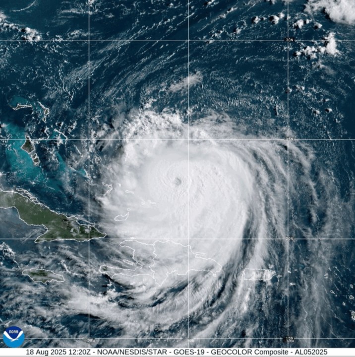
The storm reached Category 4 strength on Monday, with sustained maximum winds of 140 mph (225 kph), as it impacted the Turks and Caicos Islands and the southeast Bahamas. By Monday night, winds had decreased to 125 mph (200 kph) with Erin positioned about 690 miles (1,110 kilometers) southwest of Bermuda and approximately 780 miles (1,255 kilometers) southeast of Cape Hatteras.
Government officials in the Turks and Caicos Islands said all services were suspended on three of its islands and ordered residents there to stay home. Some ports also closed.
On North Carolina’s Outer Banks, coastal flooding was expected to begin Tuesday and continue through Thursday.
The evacuations that began Monday on Hatteras Island and Ocracoke came at the height of tourist season on the thin stretch of low-lying barrier islands that jut into the Atlantic Ocean and are increasingly vulnerable to storm surges.
A year ago, Hurricane Ernesto stayed hundreds of miles offshore yet still produced high surf and swells that caused coastal damage.
This time there are concerns that several days of heavy surf, high winds and waves could wash out parts of the main highway, the National Weather Service said. Some routes could be impassible for several days, authorities warned.
This is the first time Ocracoke has been evacuated since Hurricane Dorian struck in 2019, leaving behind the most damage in the island’s recorded history.
Tommy Hutcherson, who owns the community’s only grocery store, said the island has mostly bounced back. He’s optimistic this storm won’t be as destructive. “But you just never know. I felt the same way about Dorian and we really got smacked,” he said.
Scientists have linked the rapid intensification of hurricanes in the Atlantic to climate change. Global warming is causing the atmosphere to hold more water vapor and is spiking ocean temperatures, and warmer waters give hurricanes fuel to unleash more rain and strengthen more quickly.
Daniel Pullen, a professional photographer who lives on Hatteras Island, said he’s already lost three days of work shooting family portraits because of the evacuation order.
Pullen doesn’t plan to evacuate, fearing he could be stuck off the island for days and even weeks if the main Highway 12 washes out.
“It’s a bit like Russian roulette,” Pullen said. “Do you stay and take the chance of it hitting you? Or do you leave and take the chance of getting stuck off the island for weeks at a time? I would say the majority of Hatteras Island residents can’t afford to stay in a motel for a week or two weeks.”
Erin, the year’s first Atlantic hurricane, reached a dangerous Category 5 status Saturday with 160 mph (260 kph) winds before weakening. It is expected to remain a large hurricane into midweek.
“You’re dealing with a major hurricane. The intensity is fluctuating. It’s a dangerous hurricane in any event,” the hurricane center’s Richard Pasch said.
Bermuda will experience the most severe threat Thursday evening, said Phil Rogers, director of the Bermuda Weather Service. By then, waters could swell up to 24 feet (7.3 meters).
“Surfers, swimmers and boaters must resist the temptation to go out. The waters will be very dangerous and lives will be placed at risk,” acting Minister of National Security Jache Adams said.
Erin’s outer edges hit parts of Puerto Rico and the Virgin Islands with heavy rains and tropical storm winds Sunday, knocking out power to thousands.
___
Associated Press journalists Safiyah Riddle in Montgomery, Alabama, and Julie Walker in New York contributed.