

ORLANDO, Fla. – Central Florida is bracing for a scorching Thursday, with temperatures set to soar to levels not seen since mid-August.
THURSDAY
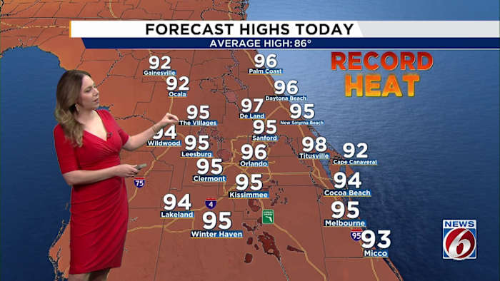
This afternoon, expect temperatures to climb into the mid-90s across the region, even reaching typically cooler coastal areas. A strong west-southwest wind will prevent the usual sea breeze from forming, pushing the heat all the way to the shoreline.
Cities such as Leesburg, Sanford, Melbourne, and Daytona Beach are poised to shatter their previous daily heat records.
The scorching temperatures, combined with dry and gusty winds, have heightened fire risks, prompting a Red Flag Warning that remains in effect until the evening.
Residents are urged to heed summer heat precautions: stay hydrated, take cooling breaks, and wear lightweight clothing to combat the intense conditions.
FRIDAY-WEEKEND
By Friday, a weak front approaching North Florida will begin increasing moisture across the state. A few showers may develop during the morning, followed by scattered afternoon and evening storms through the weekend.
Rain chances gradually increase Saturday and Sunday (30-40%) as sea breeze boundaries and the stalled front help spark more widespread activity.
Despite the return of rain chances, temperatures remain well above normal through the weekend with highs staying in the upper 80s and 90s.
Unfortunately, the added humidity will also push heat index values into the upper 90s and near 100 degrees in some areas.
NEXT WEEK
Another cold front arrives early next week, bringing a better chance for scattered storms Monday (50-60%) before slightly cooler and more seasonable temperatures return by the middle of next week.