
Share this @internewscast.com
After experiencing a very wet weekend, Savannah, Ga. started Monday with more scattered showers and storms. However, by the afternoon, our coastal areas managed to get some relief as conditions dried out somewhat.
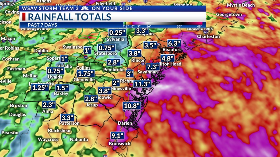
Our region, including the Coastal Empire and Lowcountry, is in dire need of a drier weather pattern. According to VIPIR Radar estimates, many areas along and to the east of Interstate-95 have been drenched with over 10 inches of rain in the last week.

A LOOK AHEAD
A few stray showers are possible Monday night with temperatures cooling into 70s.
On Tuesday afternoon, there is a possibility of more scattered showers and storms, but the likelihood of rain will be reduced compared to the past several days.
Tuesday will warm into the upper 80s to lower 90s for highs with the slightly drier patten.


Showers and storms will continue into Tuesday evening with temperatures cooling into 70s by Wednesday morning.
Moving into Wednesday and continuing through the weekend, the chance of rain will decrease further as high pressure attempts to settle in over the southeast. Expect just a few isolated showers or storms each day.
Temperatures due to the drier conditions will be able to warm into the low to mid 90s. Heat index values will be even hotter.
Stay cool any hydrated and typical summertime temperatures make a return.


TRACKING THE TROPICS
The National Hurricane Center is currently keeping track of Tropical Storm Erin and monitoring three tropical waves in the Atlantic basin for any potential development.
Tropical Storm Erin was officially identified by 11 a.m. EDT Monday, located just west of the Cape Verde Islands in the eastern Atlantic. As of 5 p.m. EDT, Erin remains a minimal tropical storm with sustained winds of 45 mph.
Wind gusts are as high as 60 mph. Erin is forecast to slowly become stronger over the next several days.


It is possible that Erin becomes the season’s first hurricane late Wednesday or sometime Thursday. Environmental conditions will support more strengthening as this system moves westward.
Erin is forecast to become a major hurricane by the weekend when it is just north of the Greater Antilles.
The overall steering pattern with a strong high located over the North Atlantic favors a westward track over the next 5-7 days. A turn to the north will be favored as it gets closer to the Bahamas within about a week to a week and a half.
This path keeps Erin safely away from the southeastern United States. Tropical Storm Erin poses no threat to the U.S. at this time, through this forecast is worth monitoring.

The other systems that the NHC is monitoring have low-end chances for development. One located just south of Nova Scotia has just a 10% chance of developing.
A second tropical wave located near Bermuda now has a low (0%) chance of developing.
The third wave located in the northern Gulf also has a low (0%) chance of development. However the Gulf wave will help to enhance rain chances over the next few days for the northern Gulf Coast.