
Share this @internewscast.com
SAVANNAH, Ga. () — A tropical system developing near eastern Cuba is increasingly likely to impact the southeastern U.S. early next week.

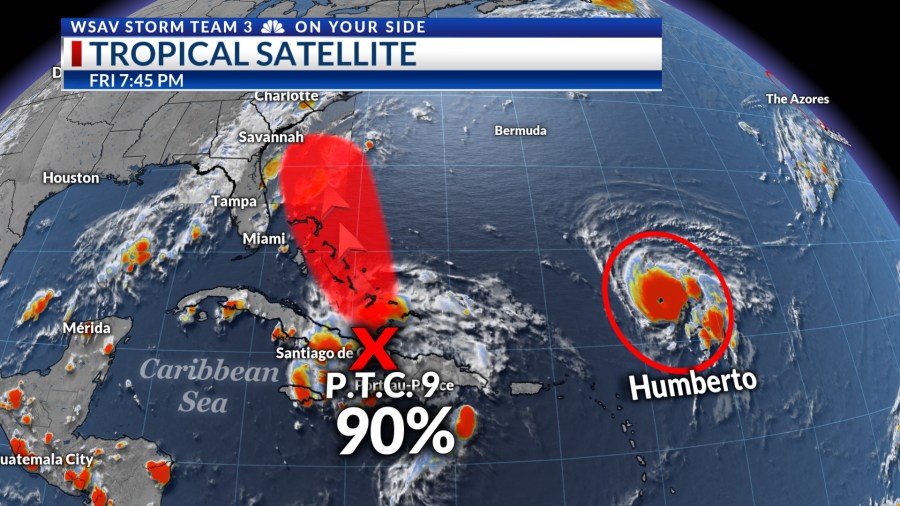
The National Hurricane Center (NHC) has been monitoring this tropical wave as it traveled along the northern Caribbean Islands. It has now been designated as Potential Tropical Cyclone Nine (P.T.C. Nine) as of 5 p.m. EDT.
As of 11 p.m. EDT, P.T.C. Nine has sustained winds of 35 mph, gusting to 45 mph, and it is moving northwest at 9 mph, positioned just north of Cuba’s eastern tip.

The potential for this system to evolve into a tropical depression or storm shortly has led to its current designation. Tropical storm watches and warnings were issued for the Bahamas on Friday evening.
There is increasing consensus among global and hurricane models that this system will move toward the southeastern U.S. coast by early next week, with a potential landfall in South Carolina by Tuesday or Wednesday.
The NHC’s official forecast predicts that P.T.C. Nine will develop into Tropical Storm Imelda by Saturday and may strengthen into a hurricane by late Sunday or Monday. The next update from the NHC is expected with the 11 p.m. EDT advisory.


There is still a lot of uncertainty in the forecast for P.T.C. Nine including the path and intensity. There is a chance that Hurricane Humberto could pull this system away from the coast before landfall. Even under that scenario, impacts will be felt along the coast early next week. The new forecast path from the NHC suggest that it is a possibility right now.
Local impacts late Monday and through Wednesday could include strong wind, minor coastal flooding, and inland flooding from prolong heavy rainfall. The forecast for the magnitude of expected impacts will change as we get a better handle of the size, path, and the speed of the foreword speed of the storm.
Hurricane Humberto will have no direct impacts on the U.S. Right now, a weakening upper-level trough is expected to have a greater influence and pull this system toward the coast initially. Though as Humberto begins to pass near Bermuda by mid week, it may allow what is now P.T.C. Nine to move back out to sea.
This weekend is the time to look over your hurricane plan and be ready to take action if needed. The main impacts would be experienced locally Late Monday, into Tuesday and Wednesday.

HURRICANE HUMBERTO
Hurricane Humberto started out Friday as a minimal Category 1 storm but rapidly intensified into a major category 3 hurricane through the afternoon.
Humberto has 145 mph sustained wind with gusts as high as 170 mph as of 11 p.m. EDT.
It is located about 520 miles northeast of San Juan, Puerto Rico. It is slowly moving west-northwest at 5 mph. It is forecast to become even stronger over the next day or so as it moves generally toward Bermuda.
The NHC forecasts that Humberto may become a category 4 hurricane with wind speeds as high as 150 mph over the weekend. Humberto should stay well east of the U.S. and just west of Bermuda early next week. It will then begin to turn northeastwardly by Wednesday, avoiding making landfall on Bermuda.