
Share this @internewscast.com
Good Evening!
SAVANNAH, Ga. () — Sunshine popped out and Sunday ended up being quite the nice one across the Coastal Empire and Lowcountry.
Temperatures peaked in the mid-80s for many areas, with breezy conditions causing gusts above 20 mph at times. Rain chances were limited to a few passing showers.
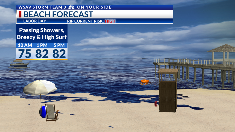
Labor Day promises to be exceptionally pleasant. Early morning temperatures will begin in the 60s and rise to the mid-80s under a clear, sunny sky.
There’s a 20% chance for some brief showers, but mostly dry weather will prevail. Winds will maintain a breezy quality at 10-15 mph, with stronger gusts likely near the shoreline.
Beachgoers should be aware of a high risk for rip currents due to robust offshore winds. Waves will measure around 3-4 feet, and a Small Craft Advisory is active until Tuesday morning for coastal waters.


This week, high pressure will dominate the weather setup. The only expected rain chances are on Wednesday and Thursday, coinciding with a frontal system, but these chances are currently around 20%.
Gradual changes are anticipated throughout the week. By its end, temperatures will approximate seasonal averages, featuring morning 70s and afternoon 90s.
The tropics feature no changes as of Sunday evening. A tropical wave moving off the coast of Africa has a 30% chance of developing into a depression or named storm over the next week.
Guidance has shifted the wave’s track to the south slightly. But, the overall environment across the Tropical Atlantic only supports very slow development.
There are currently no tropical threats for the Coastal Empire and Lowcountry.