
Share this @internewscast.com

ORLANDO, Fla. – Central Florida is set to experience a cooler Wednesday, followed by a brief period of warmer temperatures and rain over the weekend.
Weather Outlook for the Week
On Wednesday, the region will feel cooler temperatures attributed to a recent weather front. Expect occasional low cloud cover and a gentle breeze coming from the north to northwest.
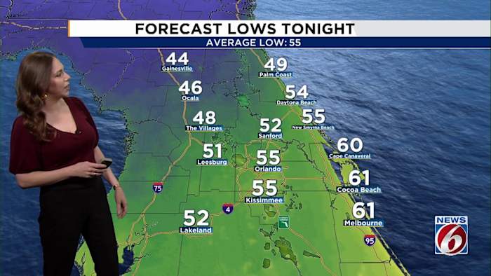
As night falls on Wednesday, temperatures are expected to dip further, reaching the upper 40s northwest of I-4, while most areas will see readings in the mid to upper 50s. Coastal areas will remain slightly warmer, with temperatures in the low 60s.
[VIDEO BELOW: Discover the cause of the giant halo around the moon]
Dry conditions will persist through Thursday and Friday as high pressure gradually diminishes. However, the weather will remain tranquil and pleasant.
Warmer weather settles in through the rest of the week, with highs closing in on 80 degrees by Friday and lows in the mid- to low 60s.
This Weekend
Meanwhile, the next Gulf low begins developing, pulling moisture toward Florida ahead of a new front expected to reach the Panhandle early Saturday.
Rain chances return this weekend as that next front approaches. It stays north of the area during the day Saturday, but moisture deepens enough to bring scattered showers (30–50%) from Orlando north Saturday afternoon and evening.
[VIDEO BELOW: Get the most out of free News 6 Weather App]
Sunday brings the highest rain coverage (around 50%) as the front slides through.
Before the front gets here, temperatures will remain much warmer than normal — in the upper 70s to low 80s.
Next Week
Monday and Tuesday turn cooler behind the front, falling into the upper 60s.
A reinforcing shot of cooler air Monday night brings an even chillier start Tuesday morning, with lows dipping into the mid- to upper 40s inland and low to mid-50s along the coast.
[VIDEO BELOW: Crazy stat from 2025 hurricane season]
Copyright 2025 by WKMG ClickOrlando – All rights reserved.