
Share this @internewscast.com
ORLANDO, Fla. – We’re now entering the latter part of the 2025 hurricane season, which is certainly welcome news. With time swiftly moving forward, it’ll be the end of October before we realize it.
This is typically the period when changes start to occur in the tropics. Similar to the beginning of the season, our focus shifts towards monitoring potential developments closer to the mainland.
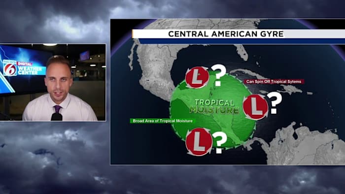
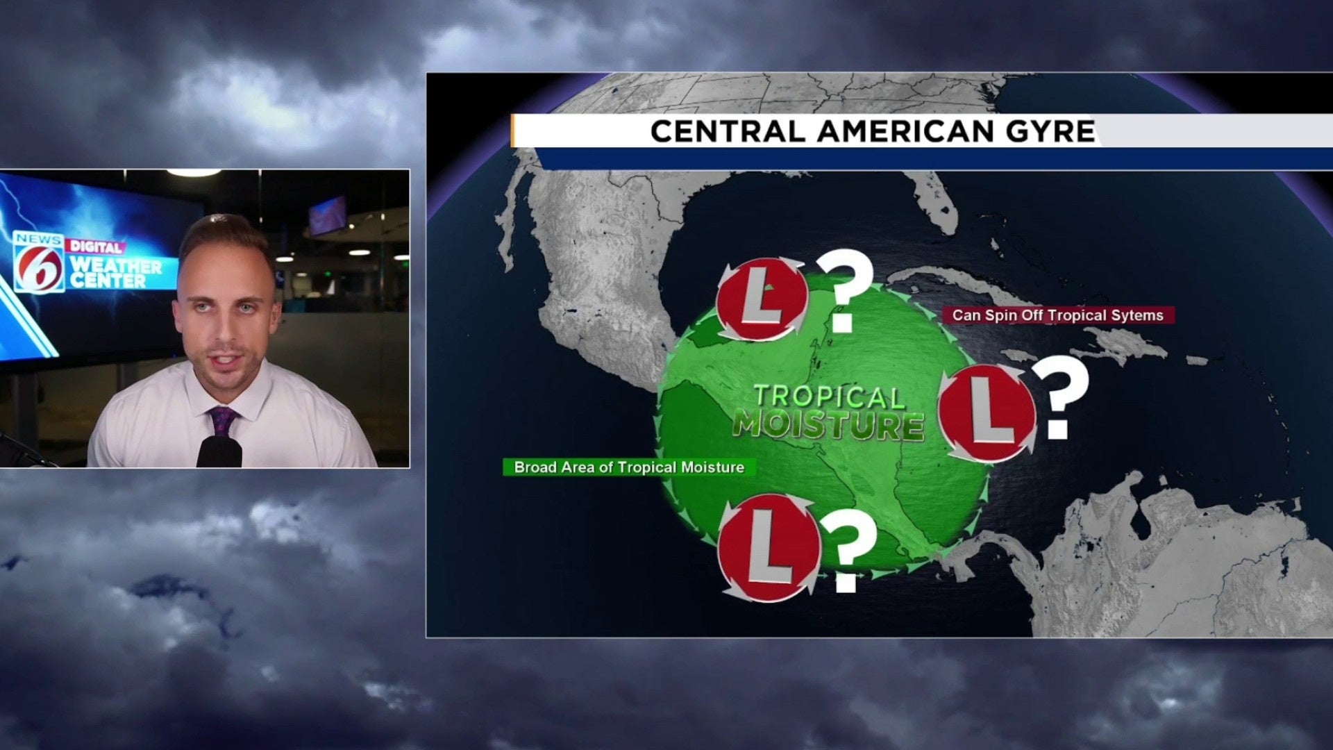
A familiar term you’ve maybe come across in the past comes to mind – the gyre. The Central American Gyre to be exact.
If you need a quick refresher on what the gyre is, there’s a detailed article that explains it thoroughly.
I want to quickly dissect what it is I’m seeing for you all, and give you some situational awareness to stew on over the next several days.
We are about to experience another passage of the Madden Julian Oscillation. This term is significant throughout the hurricane season and is a crucial factor for various weather patterns, extending beyond the tropics.
Forecast models indicate that this could be one of the most significant impacts we’ve seen. This suggests the development of favorable conditions over areas like the Gulf, the Caribbean, and parts of the Atlantic, particularly in the upper layers of the atmosphere.
The MJO promotes lift, and helps add a little extra moisture to the regions throughout the tropics.
Tropical waves and spinning systems thrive under conditions with abundant moisture, warm temperatures, and rising motion. This oscillation often signals when it’s time to watch for potential formations.
Because models think this could be a fairly aggressive pass of this lifting mechanism, we’re already seeing an enormous disruption in the flow over Central America. That’s where we watch for the gyre to start up.
Once it does, it’s a matter of time before it tries to hurl a low pressure or two, or even three in several different directions. It is without a doubt one of the trickiest features to forecast, especially if you’re watching for a tropical storm to come out of it.
The Gulf and the Caribbean are already cluttered with showers and storms, increasing the general moisture available for things to take advantage of.
Wind shear hasn’t been all that crazy in recent days either, so as our MJO comes across it could try to spark a named storm or perhaps two before October is all said and done with.
Why am I even bringing this up for everyone? Also, let me quickly answer why it is I encourage you check in with us regarding how this feature tries to establish itself and where we go from there.
The gyre is pretty synonymous with hurling some pretty nasty storms up towards populated areas.
Do you remember Helene and Milton? How about Idalia? Or maybe a bit of a throwback to hurricane Michael of 2018?
All systems brought into existence by none other than the gyre. While there’s never a guarantee, especially from this far out, anything is forming let alone coming to Florida. Typically, it raises eyebrows for us meteorologists whenever it’s in the long-range forecast. It increases our odds of someone receiving a system, and they tend to be on the stronger side the deeper into the hurricane season you go.
The date I’m pinpointing currently is Oct. 12 for things to begin to slowly come together. By Oct. 15 through the 17 is when I believe if a storm were to try to develop, we’ll be on the brink of seeing it do so.
Check back on occasion as I keep you updated through the month of October on all things tropical, especially as I watch model run by model run what the general thinking is just to our south and west.
Copyright 2025 by WKMG ClickOrlando – All rights reserved.