Residents across Victoria, New South Wales and south-west Queensland are being urged to brace for a significant burst of wet weather in the days ahead.
Forecasters say two major rainbands are set to move across the southern half of Australia and up the east coast next week, bringing widespread falls to several regions.
The Bureau of Meteorology said a rainband crossing Western Australia on Friday would track east before intensifying early next week.
“Heavier and more persistent rainfall of about 40mm to 80mm is forecast,” the bureau said.
The Murray-Darling Basin is expected to see some of the heaviest totals, with Weatherzone forecasting accumulated falls of 50mm to 100mm over the next seven days.
The basin, which includes the tributaries of the Murray and Darling rivers, is likely to be affected by the first rainband on Monday.
A second system is then expected to move through the region between Wednesday and Friday.
The wet weather outlook comes less than a fortnight after the Bureau of Meteorology said forecasts were pointing to a “strong to very strong” El Niño pattern.

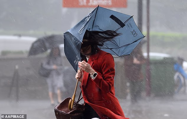
Australians in Victoria, New South Wales, and south-west Queensland have been warned to prepare for heavy rainfall (Pictured, a woman struggling with an umbrella in Sydney)

Two large rainbands – long, narrow areas of rain – are forecast to sweep across the southern half of the country and along the east coast next week
‘El Niño often brings drier conditions to central and eastern Australia in winter and spring, but Australia’s weather is also shaped by other climate factors, so outcomes can vary,’ it said.
As a result, the heavy rainfall warnings may be a surprise to Australians.
But the forecast rain is being driven by a different climate factor: the Southern Annular Mode (SAM), the north-south movement of strong westerly winds circling Antarctica.
The changes to the winds can impact rainfall, temperatures and storm systems across the Southern Hemisphere, including Australia and New Zealand.
The SAM is currently very strong, at its highest level since May 2023, drawing moisture over Australia and encouraging rainfall, according to Weatherzone.
Melbourne
Sunday: Min 5. Max 17. The chance of morning fog. Sunny afternoon. Light winds.
Monday: Min 9. Max 17. Cloudy. High chance of showers, most likely in the afternoon and evening. Winds northeasterly and light increasing to 15 to 25 km/h during the morning then turning northerly 15 to 20 km/h during the evening.

Those in the Murray-Darling Basin are expected to receive the heaviest rainfall

The basin is due to see accumulated rainfalls of 50-100mm over the next seven days
Tuesday: Min 12. Max 17. Cloudy. Very high chance of showers, most likely in the morning. Winds northerly 15 to 20 km/h becoming light during the evening.
Wednesday: Min 12. Max 17. Cloudy. Very high chance of showers. Winds northerly 15 to 25 km/h.
Thursday: Min 11. Max 16. Cloudy. Very high chance of showers. Winds northerly 20 to 30 km/h tending northwesterly during the day.
Sydney
Sunday: Min 12. Max 18. Partly cloudy. Very high chance of showers. Light winds.
Monday: Min 11. Max 19. Partly cloudy. Medium chance of showers, most likely in the morning and afternoon. Light winds.
Tuesday: Min 12. Max 21. Partly cloudy. Medium chance of showers, most likely in the afternoon and evening. Light winds becoming northeasterly 15 to 20 km/h during the day then tending northerly during the afternoon.
Wednesday: Min 14. Max 23. Mostly sunny day. High chance of showers, most likely later in the day. Light winds becoming northerly 15 to 25 km/h during the day.
Thursday: Min 16. Max 23. High chance of showers, most likely during the morning. Mostly sunny afternoon. Winds northerly 15 to 20 km/h tending northwesterly 15 to 25 km/h during the morning.

The heavy rainfall warnings may be a surprise to Australians as it comes less than two weeks after the Bureau of Meteorology said forecasts signal a ‘strong to very strong’ El Niño pattern
Brisbane
Sunday: Min 12. Max 21. Partly cloudy. Medium chance of showers, most likely in the late morning and afternoon. Light winds.
Monday: Min 12. Max 21. Partly cloudy. Medium chance of showers, most likely in the morning and afternoon. Light winds.
Tuesday: Min 13. Max 23. Partly cloudy. Medium chance of showers, most likely in the morning and afternoon. Light winds.
Wednesday: Min 13. Max 23. Partly cloudy. Slight chance of a shower. Light winds.
Thursday: Min 13. Max 25. Partly cloudy. Slight chance of a shower. Light winds.
Adelaide
Sunday: Min 10. Max 18. Partly cloudy. Slight chance of a shower in the afternoon and evening. Winds northeasterly 15 to 20 km/h.
Monday: Min 11. Max 17. Cloudy. Very high chance of showers, most likely in the afternoon and evening. Winds northeasterly 15 to 20 km/h becoming light during the morning.
Tuesday: Min 11. Max 17. Cloudy. Medium chance of showers. Light winds becoming northerly 15 to 20 km/h during the day.

But the forecast rain is being driven by a different climate factor: the Southern Annular Mode (SAM), the north-south movement of strong westerly winds circling Antarctica
Wednesday: Min 12. Max 17. Cloudy. Very high chance of showers. Winds northerly 25 to 35 km/h tending northwesterly 30 to 35 km/h during the day.
Thursday: Min 10. Max 15. Cloudy. Very high chance of showers. Winds northwesterly 30 to 35 km/h tending westerly 25 to 40 km/h during the day.
Perth
Sunday: Min 11. Max 19. Cloudy. Very high chance of showers. Winds southwesterly 15 to 20 km/h becoming light before dawn then becoming southwesterly 15 to 25 km/h in the morning.
Monday: Min 10. Max 18. Cloudy. Very high chance of showers. Light winds becoming west to northwesterly 15 to 25 km/h during the day.
Tuesday: Min 10. Max 17. Cloudy. Very high chance of showers. The chance of a thunderstorm in the morning. Winds westerly 20 to 25 km/h tending southwesterly 20 to 30 km/h during the morning then becoming light during the evening.
Wednesday: Min 9. Max 18. Cloudy. Very high chance of showers. Light winds becoming southwesterly 15 to 25 km/h during the morning.
Thursday: Min 9. Max 18. Partly cloudy. Medium chance of showers, most likely during the morning. Light winds.
Canberra
Sunday: Min 3. Max 14. Cloudy. The chance of morning fog. Medium chance of showers, most likely in the late morning and afternoon. Light winds.
Monday: Min 4. Max 15. Cloudy. Medium chance of showers, most likely in the afternoon and evening. Light winds.
Tuesday: Min 4. Max 15. Cloudy. Very high chance of rain, most likely in the afternoon and evening. Light winds becoming northwesterly 15 to 20 km/h during the day then tending northerly during the afternoon.
Wednesday: Min 7. Max 15. Cloudy. Very high chance of rain. Light winds becoming north to northwesterly 15 to 25 km/h during the day.
Thursday: Min 8. Max 15. Partly cloudy. Very high chance of showers, most likely during the morning. Winds northerly 20 to 25 km/h tending northwesterly 25 to 35 km/h during the morning.
Hobart
Sunday: Min 3. Max 12. Mostly sunny. Light winds becoming northerly 15 to 20 km/h in the morning then becoming light in the middle of the day.
Monday: Min 3. Max 15. Mostly sunny morning. Slight chance of a shower in the afternoon and evening. Light winds becoming northerly 15 to 20 km/h during the morning.
Tuesday: Min 8. Max 15. Partly cloudy. High chance of showers, most likely in the morning. Winds northerly 15 to 20 km/h becoming light during the afternoon.
Wednesday: Min 7. Max 16. Partly cloudy. Medium chance of showers, most likely later in the day. Light winds becoming northerly 15 to 20 km/h during the morning.
Thursday: Min 9. Max 16. Partly cloudy. High chance of showers. Winds northerly 15 to 25 km/h tending northwesterly during the day.
Darwin
Sunday: Min 21. Max 31. Mostly sunny. Light winds becoming north to northeasterly 15 to 20 km/h in the early afternoon then becoming light in the evening.
Monday: Min 21. Max 31. Mostly sunny. Light winds becoming north to northeasterly 15 to 20 km/h during the afternoon then becoming light during the evening.
Tuesday: Min 21. Max 31. Medium chance of showers, most likely in the morning. Mostly sunny afternoon. Light winds becoming northerly 15 to 20 km/h during the afternoon then becoming light during the evening.
Wednesday: Min 21. Max 30. Partly cloudy. Medium chance of showers. Light winds becoming north to northwesterly 15 to 20 km/h during the day.
Thursday: Min 21. Max 31. Slight chance of a shower, most likely during the morning. Mostly sunny day. Light winds becoming north to northeasterly 15 to 20 km/h during the day.