
Share this @internewscast.com
Residents in northern and central Victoria, including those in Melbourne, should brace for a day of intense rainfall and potential thunderstorms.
The Bureau of Meteorology anticipates that heavy showers will first impact Melbourne’s western suburbs this morning, gradually advancing towards the eastern areas by afternoon and evening.
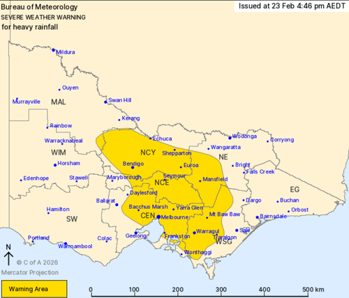
Rainfall amounts ranging from 40 to 70 millimetres over six hours are expected, prompting a severe weather alert for heavy rain across regions such as Echuca, Bendigo, Seymour, Mount Buller, Warragul, and the broader Melbourne area.
These weather conditions are projected to continue moving through the eastern parts of Victoria and may extend into southeastern New South Wales by tomorrow.
An initial flood watch has been issued for the North East, Central, and Gippsland catchments.
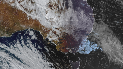
This weather system results from a low-pressure system drawing tropical moisture from central Australia, combined with a cold front moving up from the south.
Emergency services are urging communities to prepare their properties before the storm by tying down loose outdoor items, clearing gutters and downpipes and parking cars undercover or away from trees.
Motorists and commuters are warned to drive safely, allow extra travel time and be alert to allow extra travel time and stay alert for hazards. These hazards could include fallen trees, debris, damaged power lines and localised flash flooding.
“If severe weather is impacting your area, consider delaying travel where possible and staying indoors until conditions improve. Never drive through floodwater,” VICSES chief officer of operations Alistair Drayton said.
Warm and humid conditions are expected, with Melbourne set to reach a top of 25 degrees today.
Victoria had a taste of the extreme weather on Sunday, with parts of the state battered by up to 40 millimetres of rain in the 24 hours to 9am yesterday.
There was localised flash flooding in the Wodonga area, sparking 90 calls for assistance from VICSES.
All up, SES volunteers responded to about 250 requests for assistance across the state between midday on Sunday and 10am yesterday.
“Thank you to the dedicated volunteers who worked throughout last night to assist impacted communities and remain ready to respond as further storms approach this week,” Drayton said.
Communities in areas recently impacted by bushfire are warned of elevated flash flooding warnings.
Burnt ground does not absorb water effectively, meaning runoff can occur quickly and without warning, the State Control Centre said.
What was set to be a record-breaking dry summer across swaths of inland Australia has ended dramatically, with a torrential downpour bringing widespread flooding in the final days of summer.
NEVER MISS A STORY: Get your breaking news and exclusive stories first by following us across all platforms.