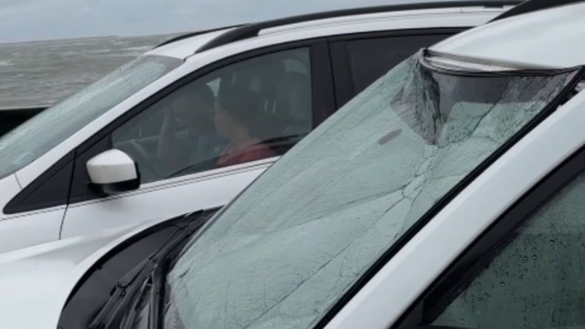

A routine ferry crossing in North Carolina became a frightening ordeal when a powerful coastal storm sent fierce winds and heavy waves crashing across the deck, shattering one vehicle’s windshield and allowing water to pour inside.
Megan Lawing had been visiting Ocracoke Island with her family when the storm battering the Outer Banks intensified on Saturday morning.
Lawing told 10 On Your Side that she arrived around 8:30 a.m., but the family did not board the ferry until approximately four hours later.
While seated inside her car, she recorded video of seawater slamming against the windshield and waves spilling across the front section of the ferry deck.
“We had front-row seats to the whole thing, and it was pretty nuts,” Lawing said. After traveling to Ocracoke every year for 18 years, she added that she had never witnessed conditions like them before.
The pounding surf struck the vehicles with enough force to cause significant damage during the crossing.
Lawing said the vehicle next to hers was hit so violently that its windshield cracked.
The driver began sounding her horn to alert the ferry crew. Staff eventually reached the car and helped escort the woman to safety, but water had already started entering the vehicle—an escalation that left Lawing increasingly frightened.

Megan Lawing was traveling with her family on Ocracoke Island when the coastal storm sweeping across the Outer Banks rapidly worsened Saturday morning

Powerful waves battered a vehicle aboard the ferry, cracking its windshield during the stormy crossing

Lawing said the ferry ride became “pretty scary” as water surged across the deck
It was only after the ferry reached shore that Lawing fully grasped how dangerous the journey had been.
“Once you got to land, it was kind of like, ‘Wow, that was actually pretty scary,’” she recalled.
Dare County officials urged people to avoid traveling because of hazardous conditions, with wind speeds reaching as high as 50 mph, according to Fox 8.
A mandatory evacuation order was issued Friday for visitors on Hatteras Island because of the threat of flooding. Dare County Emergency Management Director Drew Pearson said officials were encouraged by the public’s response.
“That was a protective measure we had to put in place to keep people safe,” Pearson said.
Pearson also cautioned residents that the next high tide on Sunday could push water onto the highways and other roads.
He urged drivers to turn around whenever they encounter standing water, whether on Highway 12 or any other route, rather than attempting to drive through it.
KEEP READING: Outrage as Islamic School Thought to Have 90 Pupils Reveals 313
Pearson advised people to safeguard their homes, stay away from both the sound and ocean sides of the island, and focus on their personal safety as the storm continued.

Dare County officials warned residents to stay off the roads as storm conditions worsened and winds climbed to 50 mph

Coastal flooding and tropical storm-force winds are expected across several states
Pearson added that the storm is expected to be ‘persisting for a few days.’
‘It’s not going in quickly,’ he said.
A major nor’easter has been forming off the US East Coast, as officials have issued flood warnings from Florida to Massachusetts.
AccuWeather Senior Meteorologist Adam Douty said: ‘The most significant coastal impacts are expected close to the center of the storm, potentially on the Outer Banks of North Carolina, southeastern Virginia and the beach communities of Maryland and Delaware.’
Wind gusts of up to 70mph may be seen from North Carolina to southern New Jersey on Monday and Tuesday, hitting coastal communities including Atlantic City, Ocean City and Virginia Beach.
The nor’easter has also triggered an official Storm Warning in the Atlantic, affecting anyone traveling 70 to 300 miles off the US East Coast around the Mid-Atlantic states.
The National Weather Service (NWS) has issued Coastal Flood Advisories in Florida, North Carolina, Virginia, Delaware and New Jersey through Wednesday, affecting more than three million people along the Atlantic.
High Surf Advisories in several locations warn that large breaking waves of roughly seven to 14 feet will be possible, creating dangerous swimming conditions and strong rip currents that pull people out into the ocean.

Residents in coastal towns and low-tying areas have been warned to prepare for days of flooding (File Image)
Forecasters warn that the storm’s dangerous impacts throughout the week will be the same regardless of whether the NWS declares it a named tropical cyclone or not and urged Americans to prepare for days of flooding, particularly during high tide.
AccuWeather expert meteorologist Elizabeth Danco added in a statement: ‘The biggest concern with this storm isn’t just how strong winds become, but how long coastal communities will have to endure them.’
‘When water is pushed toward the coast for days, it may not have enough time to drain away between high tides. That can turn what might otherwise be a manageable flooding event into a prolonged disruption, with roads repeatedly underwater and beaches losing more sand with each passing tide cycle.’
While initial forecasts suggested that the storm would weaken and start moving away from the US by Thursday, AccuWeather’s latest predictions show the nor’easter becoming ‘nearly stationary’ and prolonging coastal flooding on Wednesday and Thursday.
Coastal flooding and beach erosion are expected to spread farther north along the New Jersey coast, Long Island, New York and into southern New England.