
A vast expanse of warm water, stretching across hundreds of miles, has been detected in the Pacific Ocean, according to NASA.
The space agency utilized satellite imagery to identify this warm water mass located off the coast of South America.
Scientists warn that this development could indicate the onset of a Super El Niño, expected to materialize “later in the year.”
NASA explained, “Before an El Niño event occurs, waves of higher, warmer water travel eastward across the Pacific Ocean. Several such waves have been observed in the 2026 satellite data.”
The El Niño phenomenon has been a part of Earth’s climate system for hundreds of thousands of years.
However, current indicators suggest that this year’s El Niño could be among the most intense ever recorded.
Experts predict extreme heat ‘nearly everywhere’, with the potential for global average temperatures to rise by as much as 3°C (5.4°F) this summer.
Meanwhile, Super El Niño is expected to wreak havoc on rainfall patterns around the world.

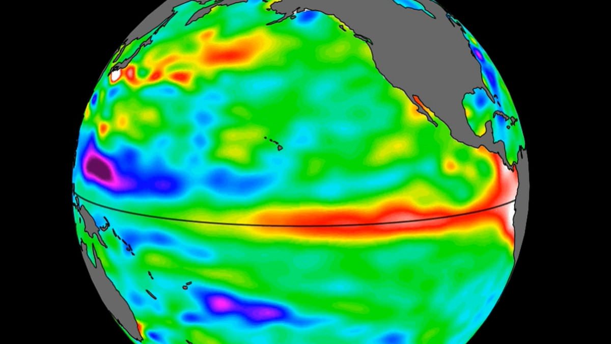
A swell of warm water hundreds of miles wide has arrived in the Pacific Ocean, NASA has revealed
The new data comes from the Sentinel–6 Michael Freilich satellite, which was launched in 2020 by NASA.
This satellite measures and maps water height for the entire ocean every 10 days, down to fractions of an inch.
In the case of El Niño, the satellite tracks what are called ‘warm Kelvin waves’.
Nadya Vinogradova Shiffer, lead program scientist at NASA Headquarters in Washington, explained: ‘NASA’s observation of El Niño uses sea level satellites like Sentinel–6 Michael Freilich to track massive Kelvin waves as they cross the Pacific, capture changes in Earth’s ocean thermodynamics, improve forecasts of weather extremes, and help communities prepare for potential coastal hazards.’
Kelvin waves typically form after brief periods when winds over the far western equatorial Pacific Ocean moving from east to west change direction.
That effect, combined with a general weakening of easterly winds along the equator, causes water in the tropics of the western Pacific to get warmer and sea levels to rise.
The wave that forms then travels east for several weeks, eventually reaching South America and causing water off the coast to heat up and rise.
An El Niño develops as multiple Kelvin waves appear over the course of several months, and the warm water accumulates off the shores of Colombia, Ecuador, and Peru, according to NASA.
In late January, a small Kelvin wave formed around Micronesia, before dissipating a few weeks later.
A new wave then emerged in early March, moving east over time.
Meanwhile, by mid–May, the seas around Peru were more than 5.9 inches (15 centimeters) higher than usual.
‘While this year’s event started a bit later than the big El Niños of 2015 and 1997, it’s beginning to catch up,’ said Josh Willis, a sea level researcher at NASA’s Jet Propulsion Laboratory.
‘We’ll see how big it gets.’
When El Niño does arrive, the World Meteorological Organisation says we can expect above–normal temperatures in ‘nearly all parts of the globe’.
The strongest heat signals are forecast across southern and western North America, Central America, the Caribbean, Europe, North Africa, and much of Asia.
Northern parts of Asia may also be warmer than usual, although the forecast there is less certain.
In the Southern Hemisphere, warmer–than–normal conditions are also expected across many areas.
Northern South America is likely to see the strongest warming, while Southern Africa is forecast to experience widespread above–normal temperatures.
In Australia, warmer conditions are mainly expected along the western, southern, and eastern coasts, with no clear trend in the north.
Tropical regions around the world are also forecast to be hotter than normal, especially Equatorial Africa and parts of Southeast Asia and the Maritime Continent.