

ORLANDO, Fla. – Central Florida is embracing a more summer-like atmosphere this week, characterized by warm temperatures, brisk onshore winds, and a growing likelihood of rain and thunderstorms as Memorial Day weekend approaches.
MONDAY
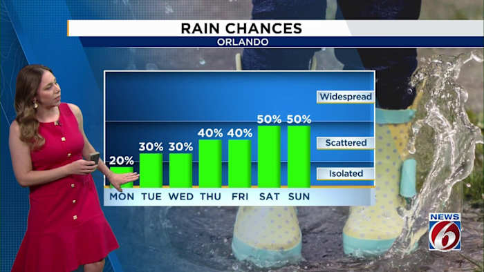
On Monday, residents can look forward to a blend of sunshine and clouds, with temperatures reaching the high 80s along the coastline and the low 90s further inland. The afternoon will bring stronger easterly winds as the sea breeze forms, potentially producing gusts between 20 and 25 mph.
There will be a chance for a few isolated to scattered showers and thunderstorms to develop in the afternoon, primarily affecting areas south of Orlando, with about a 10-20% coverage.
THIS WEEK
The main focus this week is the anticipated rise in moisture levels as we progress toward Memorial Day weekend. Expect daily chances of rain and thunderstorms to increase, particularly by Saturday and Sunday, when coverage could reach between 50% and 70% in various parts of Central Florida.
The overall setup looks very typical for late May in Florida, with scattered afternoon storms developing along the sea breeze each day.
Forecast models show deeper tropical moisture moving into the state by the holiday weekend, which could lead to more widespread showers and storms.
Even with the increasing rain chances, temperatures will stay warm with highs near 90 degrees most afternoons and humid nights continuing through the weekend.